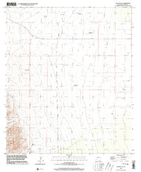
1996 Map of Gleeson SE
USGS Topo · Published 2003About this map
Water management in this arid stretch of Cochise County is defined by a network of windmills and catchment tanks, such as Ernest Tank, Rattlesnake Tank, and the Hackberry Windmill. This 1996 survey shows the high desert transition where the Mule Mountains rise in the southwest, carved by drainages like Abbot Canyon and Johnson Canyon.
Find a feature on this map
24 named features on this map. Tap any name to fly to it.
Don’t see what you’re looking for? This feature index may not catch every label — zoom into the map to look around manually.
Map Details
Editions of this 1996 Gleeson SE Map
This is the sole edition of this map. No revisions or reprints were ever made.
Other maps of this area

1902 · Bisbee
USGS Topo · 1:62,500

1910 · Bisbee
USGS Topo · 1:62,500

1914 · Douglas
USGS Topo · 1:62,500

1916 · Pearce
USGS Topo · 1:125,000

1916 · Douglas
USGS Topo · 1:125,000

1919 · Douglas
USGS Topo · 1:125,000

1922 · Swisshelm
USGS Topo · 1:62,500

1925 · Douglas
USGS Topo · 1:62,500

1925 · Gleeson
USGS Topo · 1:62,500

1927 · Bisbee
USGS Topo · 1:62,500