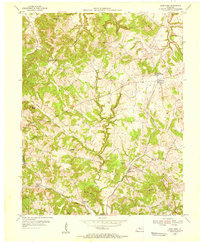
1953 Map of Glen Dean
USGS Topo · Published 1955About this map
The rugged topography of western Breckinridge County is defined by a network of creeks and prominent elevations during the early 1950s. High points such as Egypt Knob and Knob Lick Hill rise above the agricultural valleys, where small crossroads communities and rural institutions formed the backbone of local life. The settlement of McQuady and the St Marys of the Woods Sch serve as focal points for the northeastern portion of the quadrangle, while the southern reaches are marked by the oil field near Glen Dean and the Black Lick Ch. This era shows a landscape where economic activity, indicated by several Oil Wells, was integrated into a terrain heavily carved by the Rock Lick Creek and its many forks. Genealogists can find numerous cemeteries and community landmarks like Tar Fork Ch situated among the winding valley roads.
Find a feature on this map
27 named features on this map. Tap any name to fly to it.
Don’t see what you’re looking for? This feature index may not catch every label — zoom into the map to look around manually.
Map Details
Editions of this 1953 Glen Dean Map
This is the sole edition of this map. No revisions or reprints were ever made.
Other maps of this area

1928 · Hardinsburg
USGS Topo · 1:48,000

1931 · Hardinsburg
USGS Topo · 1:62,500

1932 · Fordsville
USGS Topo · 1:62,500

1934 · Cannelton
USGS Topo · 1:62,500

1947 · Hardinsburg
USGS Topo · 1:24,000

1947 · Hardinsburg
USGS Topo · 1:62,500

1953 · Mc Daniels
USGS Topo · 1:24,000

1953 · Hardinsburg
USGS Topo · 1:24,000

1953 · Kingswood
USGS Topo · 1:24,000

1953 · Cloverport
USGS Topo · 1:24,000