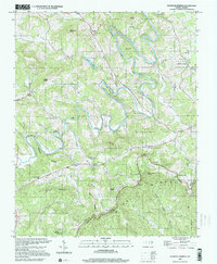
2000 Map of Glendale Springs
USGS Topo · Published 2001About this map
The South Fork New River carves a winding path through this corner of the Blue Ridge, where high-elevation settlements like Glendale Springs and Othello are connected by narrow mountain roads. This 2000 inspection shows a landscape defined by its topographical extremes, from the heights of Benge Knob and Frenches Knob down to the valley floor of Beaver Creek. The area is notably dotted with country houses of worship, including Bethel Ch and the Holy Trinity Ch, which serve as long-standing community anchors in this part of Ashe County.
Find a feature on this map
49 named features on this map. Tap any name to fly to it.
Don’t see what you’re looking for? This feature index may not catch every label — zoom into the map to look around manually.
Map Details
Editions of this 2000 Glendale Springs Map
This is the sole edition of this map. No revisions or reprints were ever made.
Other maps of this area

1889 · Wilkesboro
USGS Topo · 1:125,000

1891 · Wilkesboro
USGS Topo · 1:125,000

1893 · Cranberry
USGS Topo · 1:125,000

1895 · Cranberry
USGS Topo · 1:125,000

1899 · Cranberry
USGS Topo · 1:125,000

1902 · Cranberry
USGS Topo · 1:125,000

1936 · Blowing Rock
USGS Topo · 1:48,000

1942 · Blowing Rock
USGS Topo · 1:62,500

1953 · Winston-Salem
USGS Topo · 1:250,000

1955 · Winston-Salem
USGS Topo · 1:250,000