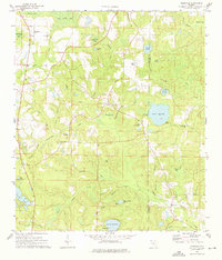
1973 Map of Glendale
USGS Topo · Published 1976About this map
Glendale and its surrounding rural hamlets are defined by a dense network of creeks and bayous along the Walton and Holmes county line during the early 1970s. The landscape is marked by religious and community hubs, including Gum Creek Ch and Friendship Ch, alongside numerous family-named water bodies like Anderson Bay and Ealum Bay. The economic and recreational use of the land is evident in the presence of the State Fish Hatchery on Lake Cassidy, as well as a Sandpit and Campground near Poley Branch. This survey includes topographic details like fence and field lines, providing a detailed view of Florida's panhandle interior before significant modern development altered the rural character of these agricultural and timber-rich hills.
Find a feature on this map
45 named features on this map. Tap any name to fly to it.
Don’t see what you’re looking for? This feature index may not catch every label — zoom into the map to look around manually.
Map Details
Editions of this 1973 Glendale Map
2 editions found
Other maps of this area

1935 · De Funiak Springs
USGS Topo · 1:48,000

1938 · De Funiak Springs
USGS Topo · 1:62,500

1948 · Ponce De Leon
USGS Topo · 1:24,000

1949 · Glendale
USGS Topo · 1:62,500

1949 · Hobbs Crossroads
USGS Topo · 1:24,000

1950 · Hobbs Cross Roads
USGS Topo · 1:24,000

1950 · Prosperity
USGS Topo · 1:24,000

1950 · Ponce De Leon
USGS Topo · 1:24,000

1951 · Glendale
USGS Topo · 1:62,500

1954 · Tallahassee
USGS Topo · 1:250,000