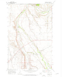
1970 Map of Glengarry
USGS Topo · Published 1973About this map
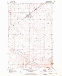
Hanover and Glengarry anchor this portion of Fergus County, where the plains meet the rising topographic relief of the Montana interior. The landscape is defined by the heavy presence of the Chicago Milwaukee St Paul and Pacific railroad, which cuts a diagonal path across the terrain, crossing numerous drainage features like Crow Coulee and Beaver Creek. The map documents a complex water management system essential to the region, including the McMillian Ditch and several instances of a Flowing Well. Distinctive geological and cultural landmarks such as Indian Rock, The Point, and The Gap provide specific points of interest for local historians. This 1970s record highlights the infrastructure of a rural community tied to the rails and the creek beds of Cottonwood Creek and Coyote Creek.
Find a feature on this map
24 named features on this map. Tap any name to fly to it.
Don’t see what you’re looking for? This feature index may not catch every label — zoom into the map to look around manually.
Map Details
Editions of this 1970 Glengarry Map
This is the sole edition of this map. No revisions or reprints were ever made.
Other maps of this area

1889 · Big Snowy Mountain
USGS Topo · 1:250,000

1893 · Big Snowy Mountain
USGS Topo · 1:250,000
1941 · Lewistown
USGS Topo · 1:62,500
1944 · Lewistown
USGS Topo · 1:62,500

1954 · Roundup
USGS Topo · 1:250,000

1954 · Lewistown
USGS Topo · 1:250,000

1958 · Roundup
USGS Topo · 1:250,000

1959 · Lewistown
USGS Topo · 1:250,000
1970 · Danvers
USGS Topo · 1:24,000
1970 · Moore
USGS Topo · 1:24,000