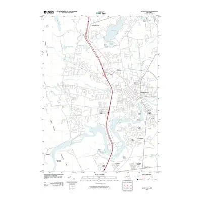
2010 Map of Glens Falls
USGS Topo · Published 2010About this map
Glens Falls and its surrounding communities are defined by the winding course of the Hudson River, which carves through the southern landscape near Pruyns Island and Haviland Cove Beach. This 2010 topographic survey documents the dense urban expansion of the city alongside its suburban neighbors, West Glens Falls and South Glens Falls. To the north, the terrain transitions into the elevations of French Mountain and the Luzerne Mountains, where residential growth meets recreational water bodies like Glen Lake and Lake Sunnyside. Local genealogists will find several burial grounds noted, including Saint Marys Cemetery and the Friends Cemetery. The map also captures specialized infrastructure such as the Butler Storage Reservoir and the Wilkie Intake Reservoir, illustrating the area's managed water systems and complex road network.
Find a feature on this map
71 named features on this map. Tap any name to fly to it.
Don’t see what you’re looking for? This feature index may not catch every label — zoom into the map to look around manually.
Map Details
Editions of this 2010 Glens Falls Map
This is the sole edition of this map. No revisions or reprints were ever made.
Other maps of this area

1895 · Glens Falls
USGS Topo · 1:62,500

1897 · Glens Falls
USGS Topo · 1:62,500

1900 · Schuylerville
USGS Topo · 1:62,500

1902 · Saratoga
USGS Topo · 1:62,500

1903 · Luzerne
USGS Topo · 1:62,500

1935 · Gansevoort
USGS Topo · 1:24,000
1935 · Fort Miller
USGS Topo · 1:24,000

1935 · Corinth
USGS Topo · 1:24,000

1938 · Glens Falls
USGS Topo · 1:62,500
1940 · Schuylerville
USGS Topo · 1:62,500