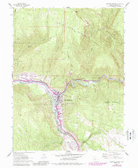
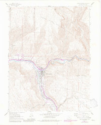
1961 Map of Glenwood Springs
USGS Topo · Published 1988About this map
Glenwood Springs sits at the dramatic confluence of the Colorado River and the Roaring Fork River, serving as a central hub for transportation and early industrial development. The map reveals a landscape shaped by water and transit, from the Atkinson Canal following the riverbanks to the winding Aqueduct and Telephone Trail traversing the steeper slopes. Industrial history is evident in the south at Cardiff, where coke ovens and local quarries reflect the area’s resource extraction roots. Cultural and civic life is anchored by landmarks like the Glenwood Springs fish hatchery, the Glenwood Springs golf course, and Rosebud Cem. To the east, the steep walls of Glenwood Canyon provide a corridor for travel and utility lines through the White River National Forest, while the developed valley floors include the Glenwood Airport and Valley View Hospital.
Find a feature on this map
39 named features on this map. Tap any name to fly to it.
Don’t see what you’re looking for? This feature index may not catch every label — zoom into the map to look around manually.
Map Details
Editions of this 1961 Glenwood Springs Map
6 editions found
Other maps of this area

1927 · Glenwood Springs
USGS Topo · 1:125,000

1930 · Glenwood Springs
USGS Topo · 1:125,000

1957 · Leadville
USGS Topo · 1:250,000

1959 · Leadville
USGS Topo · 1:250,000

1960 · Leadville
USGS Topo · 1:250,000

1961 · Cattle Creek
USGS Topo · 1:24,000

1961 · Carbondale
USGS Topo · 1:24,000

1961 · Shoshone
USGS Topo · 1:24,000

1961 · Glenwood Springs
USGS Topo · 1:24,000

1962 · Leadville
USGS Topo · 1:250,000