
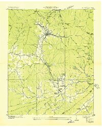
1935 Map of Gobey
USGS Topo · Published 1935About this map
The Lumber Company railroads snake through the deep hollows of Morgan County in this 1935 survey, illustrating the industrial pulse of the Cumberland Plateau during the mid-depression era. The Emory River serves as the central artery for the region, bordered by the Southern railroad line and a network of logging spurs that reached into the timber-heavy slopes of Justice Mountain and Bird Mountain.
Find a feature on this map
54 named features on this map. Tap any name to fly to it.
Don’t see what you’re looking for? This feature index may not catch every label — zoom into the map to look around manually.
Map Details
Editions of this 1935 Gobey Map
This is the sole edition of this map. No revisions or reprints were ever made.
Other maps of this area

1893 · Briceville
USGS Topo · 1:125,000

1895 · Wartburg
USGS Topo · 1:125,000

1895 · Briceville
USGS Topo · 1:125,000

1896 · Wartburg
USGS Topo · 1:125,000

1896 · Briceville
USGS Topo · 1:125,000

1935 · Camp Austin
USGS Topo · 1:24,000

1935 · Lancing
USGS Topo · 1:24,000

1935 · Pilot Mountain
USGS Topo · 1:24,000

1936 · Hogbell Gap
USGS Topo · 1:24,000
1936 · Petros
USGS Topo · 1:24,000