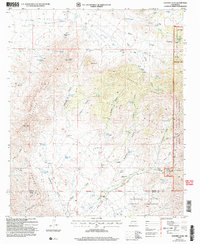
2004 Map of Godfrey Peak
USGS Topo · Published 2006About this map
Godfrey Hills and the prominent Godfrey Peak dominate this landscape on the border of Lincoln and Otero counties. This mid-2000s survey illustrates a rugged ranching and conservation environment where the Mescalero Apache Indian Reservation meets the Lincoln National Forest. The map is particularly rich in water-resource data, noting a complex system of windmills and wells essential for high-desert livestock operations, including Hall Windmill, Gamble Windmill, and New Brownfield Well.
Find a feature on this map
62 named features on this map. Tap any name to fly to it.
Don’t see what you’re looking for? This feature index may not catch every label — zoom into the map to look around manually.
Map Details
Editions of this 2004 Godfrey Peak Map
This is the sole edition of this map. No revisions or reprints were ever made.
Other maps of this area

1916 · Tularosa
USGS Topo · 1:125,000

1918 · Oscura Peak
USGS Topo · 1:125,000

1938 · Carrizozo
USGS Topo · 1:48,000

1943 · Carrizozo
USGS Topo · 1:62,500

1947 · Three Rivers
USGS Topo · 1:62,500

1948 · Chihuahua Ranch
USGS Topo · 1:62,500

1950 · Three Rivers
USGS Topo · 1:24,000

1950 · Oscura
USGS Topo · 1:24,000

1950 · Carrizozo
USGS Topo · 1:62,500

1950 · Sierra Blanca Peak
USGS Topo · 1:62,500