Old Maps of Lincoln County, New Mexico
Explore 628 old maps of Lincoln County, spanning from 1916 to today. These high-resolution historic maps reveal how streets, neighborhoods, landmarks, and natural features evolved over time — perfect for genealogy, metal detecting, research, and local history exploration.
What you can do with these maps:
- See how Lincoln County changed over time: Compare historical maps to modern-day views to trace roads, homesites, rail lines & more.
- View detailed metadata: Each map includes creators, publishers, year, scale, and archive source.
- Overlay maps with satellite & LiDAR: Visualize the past alongside modern tools to explore terrain & human change.
- Trusted historical sources: Maps sourced from the USGS, Library of Congress, and other archives.
- Access maps your way: View online, download high-res files, or order prints for personal or research use.
Start exploring old maps of Lincoln County to uncover forgotten places, hidden landmarks, and the deep history beneath your feet.
Lincoln County, NM maps
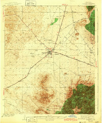
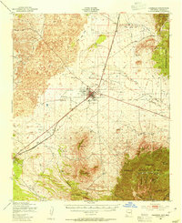
(628)- 1916 Map of Tularosa
 1916 Tularosa1916 Print · USGSNew Mexico ranching and railroading define this pre-war survey of the valley during its early years of statehood. Genealogists and historians can trace family landholdings at Jackson Ranch and Chosa Ranch or follow the path of the El Paso and Southwestern railroad.2 unique versions available
 - 1918 Map of Oscura Peak
 1918 Oscura Peak1918 Print · USGSSocorro and Lincoln counties appear here in the early twentieth century as a landscape of isolated ranches and rugged mining prospects. Genealogists and historians can locate early family-named sites like Bursum, Estey, and Chihuahua Ranch near the Oscura Range.
 - 1934 Map of Capitan
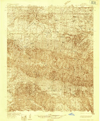
 1934 Capitan1934 Print · USGSLincoln County’s high-mountain ranching and mining country is captured in the mid-1930s, showing the early infrastructure of the Sacramento Mountains. Researchers can trace the layout of White Oaks, locate the Encinoso Cem, and find landmarks like Hudner Airport.3 unique versions available
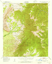
 - 1935 Map of Capitan Mountains
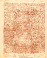
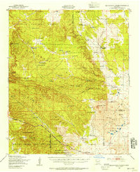
 1935 Capitan Mountains1935 Print · USGSLincoln County ranching and public health history are preserved here in the mid-1930s, dominated by the massif of the Capitan Mountains. Researchers can trace early family homesteads like Merchant Ranch and the localized community centers of Richardson School and the U S Marine Hospital Reservation.2 unique versions available
 - 1936 Map of Arabela
 1936 Arabela1936 Print · USGSRanching and rural education define this mid-1930s survey of the Arabela region near the Capitan Mountains. Genealogists and historians can locate family holdings like Purcella Ranch and several local institutions including Plainview School and Escondido Spring School.4 unique versions available
 - 1937 Map of Capitan
 1937 Capitan1937 Print · USGSLincoln County in the mid-thirties is a landscape of high-altitude ranching and specialized federal outposts. Genealogists and historians can trace family landholdings and community sites such as Le Baron Ranch, Mesa Sch, and the Enginoso Cem.3 unique versions available
 - 1938 Map of Carrizozo
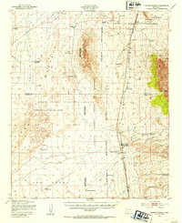
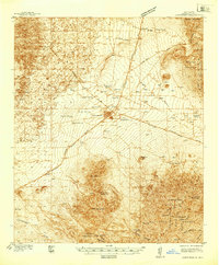 1938 Carrizozo1938 Print · USGSLincoln County in the late 1930s centers on the rail hub of Carrizozo as it transitions from a mining-era landscape to a modern ranching community. Genealogists and local historians can locate early family holdings like Spencer Ranch and remote sites such as Degners Mine.
 - 1940 Map of Capitan Mountains
 1940 Capitan Mountains1940 Print · USGSLincoln County ranching and forestry are caught in detail during the mid-1930s, showing a landscape of high-altitude lodges and remote family outposts. Genealogists can locate family-named sites like the Hinchley Ranch and Morris Ranch or the U S Marine Hospital Reservation.2 unique versions available
 - 1942 Map of Arabela
 1942 Arabela1942 Print · USGSLincoln County ranching life in the 1930s is preserved here, centered on the small community of Arabela and the surrounding high-desert arroyos. Genealogists can trace family holdings like the Russell Bird Ranch and Purcella Ranch or locate the Plainview Sch.2 unique versions available
 - 1943 Map of Carrizozo
 1943 Carrizozo1943 Print · USGSCarrizozo and the high desert of Lincoln County are captured here just before the mid-century, centered on a busy junction of the Southern Pacific railroad. Genealogists and historians can trace legacy holdings like Spencer Ranch and Roberts Ranch or the early layout of the Carrizozo Country Club.
 - 1947 Map of Three Rivers, 1954 Print
 1947 Three Rivers1954 Print · USGSThe Southern Pacific railroad and early military proving grounds define this Otero County landscape in the late forties. Trace family holdings like Falls Ranch and Hatchet Ranch alongside rail stops at Oscura and North Siding.2 unique versions available
 - 1947 Map of Capitol Peak, 1955 Print
 1947 Capitol Peak1955 Print · USGSThe northern reaches of the San Andres Mountains appear at the dawn of the atomic age, as the White Sands Proving Ground was being established. Researchers can trace remote water sources like Malpais Spring and the complex terrain of the Lava Bed and Mockingbird Gap.
 - 1948 Map of Broken Back Crater, 1954 Print
 1948 Broken Back Crater1954 Print · USGSThe Socorro County desert meets mid-century military history in the late 1940s. Genealogists and historians can trace ranching life at Harvey Ranch Headquarters or find early military markers within the White Sands Proving Ground.2 unique versions available
 - 1948 Map of Chihuahua Ranch, 1954 Print
 1948 Chihuahua Ranch1954 Print · USGSLincoln County was a center for military testing and cattle ranching in the late 1940s. Genealogists and researchers can trace family-named sites like Barnes Ranch and Withers Ranch alongside the Oscura Coal Mine (Abandoned).
 - 1948 Map of Mockingbird Gap, 1955 Print
 1948 Mockingbird Gap1955 Print · USGSHigh-desert ranching meets Cold War military testing in this late 1940s survey of the Oscura Mountains. Researchers can trace remote outposts like A D Helm Ranch and Estes City alongside early installations for the White Sands Proving Ground.2 unique versions available
 - 1950 Map of Oscura
 1950 Oscura1950 Print · USGSMid-century Lincoln County is shown here as a landscape of remote rail sidings and military expansion. You can trace the Southern Pacific line through Oscura and locate high-desert water sources like Malagro Springs and Norton Well.
 - 1950 Map of Carrizozo, 1954 Print
 1950 Carrizozo1954 Print · USGSCarrizozo and the surrounding high desert of Lincoln County are captured here at mid-century, centered on the Southern Pacific rail junction. Researchers can trace local history through Evergreen Cemetery, the Junction Mine, and old sidings like Robsart.4 unique versions available
 - 1950 Map of Little Black Peak, 1954 Print
 1950 Little Black Peak1954 Print · USGSLincoln County and Socorro County meet at the edge of the high desert in this mid-century survey. Trace the route of the Southern Pacific railroad past Little Black Peak and through the volcanic expanse of The Malpais.3 unique versions available
 - 1950 Map of Sierra Blanca Peak, 1955 Print
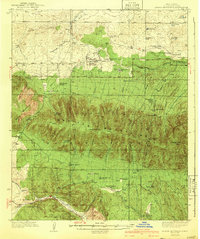
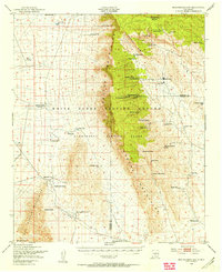
 1950 Sierra Blanca Peak1955 Print · USGSThe high Sacramento Mountains are documented at mid-century as this area was managed by federal and tribal authorities. Researchers can trace remote canyons and water sources like Cienegita Spring, Three Rivers, and the slopes of Sierra Blanca Peak.2 unique versions available
 - 1954 Map of Tularosa, 1963 Print
 1954 Tularosa1963 Print · USGSSouth-central New Mexico in the early fifties shows a landscape of desert basins and high peaks under heavy military and water-reclamation use. Trace the path of the Atchison Topeka and Santa Fe Railway past San Marcial and into the massive White Sands Proving Ground.4 unique versions available
 - 1954 Map of Fort Sumner, 1964 Print
 1954 Fort Sumner1964 Print · USGSEast-central New Mexico's ranching and rail heartland is captured here in the mid-1950s, centered on the strategic junctions of the high plains. Researchers can trace the development of early highway networks and rail towns like Vaughn, Fort Sumner, and the copper operations at Guadalupe Mine.3 unique versions available
 - 1955 Map of Roswell, 1974 Print
 1955 Roswell1974 Print · USGSSoutheastern New Mexico is shown in transition during the mid-fifties, from the Pecos Valley ranching hubs to the high timber of the Sacramento Mountains. Researchers can trace the Atchison Topeka and Santa Fe RR through Roswell and Hagerman or locate the old barracks at Ft Stanton.3 unique versions available
 - 1958 Map of Fort Sumner
 1958 Fort Sumner1958 Print · USGSEast-central New Mexico in the mid-fifties is captured here as a sprawling landscape of high mesas and cattle ranching. Researchers can trace the convergence of the Southern Pacific railroad at Vaughn and locate family landmarks like Borica School or Marquez Ranch.
 - 1958 Map of Roswell
 1958 Roswell1958 Print · USGSThe High Plains and mountain peaks of New Mexico are captured here during the mid-fifties, showing the region before the closure of Walker Air Force Base. Researchers can trace the ranching and rail landscape from Lincoln to the Pecos River valley through Hagerman and Lake Arthur.
 - 1958 Map of Tularosa
 1958 Tularosa1958 Print · USGSSouthern New Mexico in the late fifties shows a landscape of military expansion and deep-rooted river settlements. Trace family history in Truth or Consequences or locate the ruins of San Marcial and the remote Dusty Post Office.2 unique versions available
Showing maps 1-25 of 628
Top cities of Lincoln County
- Ruidoso historical maps
- Alto historical maps
- Ruidoso Downs historical maps
- Capitan historical maps
- Carrizozo historical maps
- Corona historical maps
Frequently asked questions
- What are the different types of historical maps available for Lincoln County?
- What is the oldest map of Lincoln County?
- Where can I purchase historical maps of Lincoln County for my home or office?
- Where can I download high-res historical maps of Lincoln County?
- Are there historical topographic maps available for Lincoln County?
- Is there historical aerial imagery available for Lincoln County?
- Where are historical maps of Lincoln County sourced from?