1970s Maps of Lincoln County, New Mexico
Explore 11 historic maps of Lincoln County from the 1970s. These maps offer a rare glimpse into what life looked like during the 1970s — showing old roads, neighborhoods, homes, and landmarks that have changed or disappeared over time.
Whether you're researching your family's past, planning a metal detecting trip, or studying how Lincoln County's landscape evolved across the 1970s, these high-resolution maps are a powerful tool for exploring the history of this region.
- Focus on a specific era: All maps on this page are from the 1970s, giving you a focused view of this time period.
- See what’s changed: Compare century-old streets, trails, and buildings to today's modern landscape using overlays and satellite layers.
- Research with precision: Use these maps for genealogy, historical research, land use analysis, or educational projects.
- View, download, or print: Maps are fully viewable online in high resolution, and can be downloaded or printed for your own records.
Start exploring Lincoln County's history through authentic maps from the 1970s. This is your window into the past.
Lincoln County, NM maps
(11)- 1973 Map of Ancho, 1977 Print
 1973 Ancho1977 Print · USGSThe high-desert terrain of Lincoln County comes into focus in the early 1970s, as ranching and rail infrastructure define the landscape. Researchers can trace the layout of Ancho, locate family landmarks like Miller Ranch, and identify historical mining sites including the Jicarilla Mine.
 - 1973 Map of Jacob Spring, 1977 Print
 1973 Jacob Spring1977 Print · USGSLincoln County ranching life is well-documented in this early 1970s survey of the high mountain foothills. Researchers can trace family-named sites such as Lacey Ranch and Wedding Ranch, alongside unique landmarks like Give-A-Damn Creek and Encinozo Cem.
 - 1973 Map of Nogal, 1977 Print
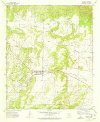
 1973 Nogal1977 Print · USGSLincoln County ranching and mining country are documented here in the early seventies, centered on the community of Nogal. Genealogists and historians can trace family locations at Silva Ranch and Peralta Ranch or locate the American Mine.
 - 1973 Map of Chupadero Mountain, 1977 Print
 1973 Chupadero Mountain1977 Print · USGSHigh desert ranching and mountain terrain in Lincoln County come to life in this early 1970s survey. Genealogists and local historians can locate the Carrabajal Cem, the Gnatkowski Ranch, and remote water markers like Soda Windmill.
 - 1973 Map of White Oaks North, 1978 Print
 1973 White Oaks North1978 Print · USGSThe Jicarilla Mountains were a focal point for mining and ranching in Lincoln County during the early 1970s. Genealogists and local historians can trace family locations at Ramsdale Place or Foster Ranch and find old burial grounds at Jicarilla Cem.2 unique versions available
 - 1973 Map of Jicarilla Peak, 1978 Print
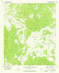
 1973 Jicarilla Peak1978 Print · USGSLincoln County ranching and forest lands are documented in the early 1970s, showing a landscape of high peaks and seasonal water draws. Researchers can trace family history at the Patos Cemetery and locate historic holdings like Davis Ranch or Eldridge Ranch.
 - 1973 Map of Capitan, 1978 Print
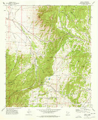
 1973 Capitan1978 Print · USGSCapitan and its surrounding ranchlands are captured here in the early 1970s as the local community balanced its mining history with national forest management. Researchers can locate family landmarks like Flatley Ranch, the old mining area of Coalora, and the small Cem north of town.
 - 1973 Map of White Oaks South, 1992 Print
 1973 White Oaks South1992 Print · USGSThe high peaks of the Lincoln National Forest come into focus in the early 1970s, revealing a landscape shaped by mining and cattle ranching. Trace local genealogy and history through the Old Abe Mines, the Cedarvale Cem, and family-named landmarks like Robinson Ranch.
 - 1979 Map of Fort Sumner
 1979 Fort Sumner1979 Print · USGSThe Pecos River valley in the late seventies reveals a landscape shaped by irrigation and the rail lines of the Atchison Topeka and Santa Fe. Genealogists and historians can trace small communities like Taiban and Yeso alongside landmarks like The Caprock.
 - 1979 Map of Roswell
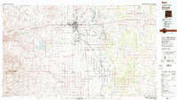 1979 Roswell1979 Print · USGSThe Pecos River valley and the city of Roswell are shown here in the late seventies as the region balanced aviation growth with agricultural heritage. Trace the transition of local sites like Roswell Industrial Air Center and the Atchison Topeka and Santa Fe rail line.
 - 1979 Map of Salt Creek
 1979 Salt Creek1979 Print · USGSChaves County's high plains and river valleys are captured here in the late seventies as the region balanced ranching life with historic aerospace milestones. Trace the Atchison Topeka and Santa Fe Railroad past Elkins or locate the Dr Robert Goddard Original Rocket Tower Site.
End of results
Showing maps 1-11 of 11
Top cities of Lincoln County
- Ruidoso historical maps
- Alto historical maps
- Ruidoso Downs historical maps
- Capitan historical maps
- Carrizozo historical maps
- Corona historical maps
Frequently asked questions
- What are the different types of historical maps available for Lincoln County?
- What is the oldest map of Lincoln County?
- Where can I purchase historical maps of Lincoln County for my home or office?
- Where can I download high-res historical maps of Lincoln County?
- Are there historical topographic maps available for Lincoln County?
- Is there historical aerial imagery available for Lincoln County?
- Where are historical maps of Lincoln County sourced from?