1950s Maps of Lincoln County, New Mexico
Explore 10 historic maps of Lincoln County from the 1950s. These maps offer a rare glimpse into what life looked like during the 1950s — showing old roads, neighborhoods, homes, and landmarks that have changed or disappeared over time.
Whether you're researching your family's past, planning a metal detecting trip, or studying how Lincoln County's landscape evolved across the 1950s, these high-resolution maps are a powerful tool for exploring the history of this region.
- Focus on a specific era: All maps on this page are from the 1950s, giving you a focused view of this time period.
- See what’s changed: Compare century-old streets, trails, and buildings to today's modern landscape using overlays and satellite layers.
- Research with precision: Use these maps for genealogy, historical research, land use analysis, or educational projects.
- View, download, or print: Maps are fully viewable online in high resolution, and can be downloaded or printed for your own records.
Start exploring Lincoln County's history through authentic maps from the 1950s. This is your window into the past.
Lincoln County, NM maps
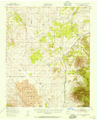
(10)- 1950 Map of Oscura
 1950 Oscura1950 Print · USGSMid-century Lincoln County is shown here as a landscape of remote rail sidings and military expansion. You can trace the Southern Pacific line through Oscura and locate high-desert water sources like Malagro Springs and Norton Well.
 - 1950 Map of Carrizozo, 1954 Print
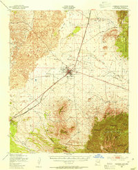 1950 Carrizozo1954 Print · USGSCarrizozo and the surrounding high desert of Lincoln County are captured here at mid-century, centered on the Southern Pacific rail junction. Researchers can trace local history through Evergreen Cemetery, the Junction Mine, and old sidings like Robsart.4 unique versions available
 - 1950 Map of Little Black Peak, 1954 Print
 1950 Little Black Peak1954 Print · USGSLincoln County and Socorro County meet at the edge of the high desert in this mid-century survey. Trace the route of the Southern Pacific railroad past Little Black Peak and through the volcanic expanse of The Malpais.3 unique versions available
 - 1950 Map of Sierra Blanca Peak, 1955 Print
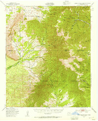 1950 Sierra Blanca Peak1955 Print · USGSThe high Sacramento Mountains are documented at mid-century as this area was managed by federal and tribal authorities. Researchers can trace remote canyons and water sources like Cienegita Spring, Three Rivers, and the slopes of Sierra Blanca Peak.2 unique versions available
 - 1954 Map of Tularosa, 1963 Print
 1954 Tularosa1963 Print · USGSSouth-central New Mexico in the early fifties shows a landscape of desert basins and high peaks under heavy military and water-reclamation use. Trace the path of the Atchison Topeka and Santa Fe Railway past San Marcial and into the massive White Sands Proving Ground.4 unique versions available
 - 1954 Map of Fort Sumner, 1964 Print
 1954 Fort Sumner1964 Print · USGSEast-central New Mexico's ranching and rail heartland is captured here in the mid-1950s, centered on the strategic junctions of the high plains. Researchers can trace the development of early highway networks and rail towns like Vaughn, Fort Sumner, and the copper operations at Guadalupe Mine.3 unique versions available
 - 1955 Map of Roswell, 1974 Print
 1955 Roswell1974 Print · USGSSoutheastern New Mexico is shown in transition during the mid-fifties, from the Pecos Valley ranching hubs to the high timber of the Sacramento Mountains. Researchers can trace the Atchison Topeka and Santa Fe RR through Roswell and Hagerman or locate the old barracks at Ft Stanton.3 unique versions available
 - 1958 Map of Fort Sumner
 1958 Fort Sumner1958 Print · USGSEast-central New Mexico in the mid-fifties is captured here as a sprawling landscape of high mesas and cattle ranching. Researchers can trace the convergence of the Southern Pacific railroad at Vaughn and locate family landmarks like Borica School or Marquez Ranch.
 - 1958 Map of Roswell
 1958 Roswell1958 Print · USGSThe High Plains and mountain peaks of New Mexico are captured here during the mid-fifties, showing the region before the closure of Walker Air Force Base. Researchers can trace the ranching and rail landscape from Lincoln to the Pecos River valley through Hagerman and Lake Arthur.
 - 1958 Map of Tularosa
 1958 Tularosa1958 Print · USGSSouthern New Mexico in the late fifties shows a landscape of military expansion and deep-rooted river settlements. Trace family history in Truth or Consequences or locate the ruins of San Marcial and the remote Dusty Post Office.2 unique versions available
End of results
Showing maps 1-10 of 10
Top cities of Lincoln County
- Ruidoso historical maps
- Alto historical maps
- Ruidoso Downs historical maps
- Capitan historical maps
- Carrizozo historical maps
- Corona historical maps
Frequently asked questions
- What are the different types of historical maps available for Lincoln County?
- What is the oldest map of Lincoln County?
- Where can I purchase historical maps of Lincoln County for my home or office?
- Where can I download high-res historical maps of Lincoln County?
- Are there historical topographic maps available for Lincoln County?
- Is there historical aerial imagery available for Lincoln County?
- Where are historical maps of Lincoln County sourced from?