1940s Maps of Lincoln County, New Mexico
Explore 8 historic maps of Lincoln County from the 1940s. These maps offer a rare glimpse into what life looked like during the 1940s — showing old roads, neighborhoods, homes, and landmarks that have changed or disappeared over time.
Whether you're researching your family's past, planning a metal detecting trip, or studying how Lincoln County's landscape evolved across the 1940s, these high-resolution maps are a powerful tool for exploring the history of this region.
- Focus on a specific era: All maps on this page are from the 1940s, giving you a focused view of this time period.
- See what’s changed: Compare century-old streets, trails, and buildings to today's modern landscape using overlays and satellite layers.
- Research with precision: Use these maps for genealogy, historical research, land use analysis, or educational projects.
- View, download, or print: Maps are fully viewable online in high resolution, and can be downloaded or printed for your own records.
Start exploring Lincoln County's history through authentic maps from the 1940s. This is your window into the past.
Lincoln County, NM maps
(8)- 1940 Map of Capitan Mountains
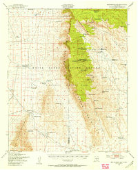
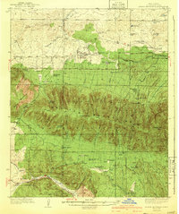 1940 Capitan Mountains1940 Print · USGSLincoln County ranching and forestry are caught in detail during the mid-1930s, showing a landscape of high-altitude lodges and remote family outposts. Genealogists can locate family-named sites like the Hinchley Ranch and Morris Ranch or the U S Marine Hospital Reservation.2 unique versions available
 - 1942 Map of Arabela
 1942 Arabela1942 Print · USGSLincoln County ranching life in the 1930s is preserved here, centered on the small community of Arabela and the surrounding high-desert arroyos. Genealogists can trace family holdings like the Russell Bird Ranch and Purcella Ranch or locate the Plainview Sch.2 unique versions available
 - 1943 Map of Carrizozo
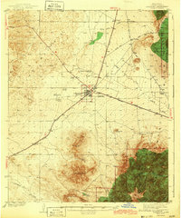 1943 Carrizozo1943 Print · USGSCarrizozo and the high desert of Lincoln County are captured here just before the mid-century, centered on a busy junction of the Southern Pacific railroad. Genealogists and historians can trace legacy holdings like Spencer Ranch and Roberts Ranch or the early layout of the Carrizozo Country Club.
 - 1947 Map of Three Rivers, 1954 Print
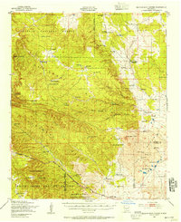
 1947 Three Rivers1954 Print · USGSThe Southern Pacific railroad and early military proving grounds define this Otero County landscape in the late forties. Trace family holdings like Falls Ranch and Hatchet Ranch alongside rail stops at Oscura and North Siding.2 unique versions available
 - 1947 Map of Capitol Peak, 1955 Print
 1947 Capitol Peak1955 Print · USGSThe northern reaches of the San Andres Mountains appear at the dawn of the atomic age, as the White Sands Proving Ground was being established. Researchers can trace remote water sources like Malpais Spring and the complex terrain of the Lava Bed and Mockingbird Gap.
 - 1948 Map of Broken Back Crater, 1954 Print
 1948 Broken Back Crater1954 Print · USGSThe Socorro County desert meets mid-century military history in the late 1940s. Genealogists and historians can trace ranching life at Harvey Ranch Headquarters or find early military markers within the White Sands Proving Ground.2 unique versions available
 - 1948 Map of Chihuahua Ranch, 1954 Print
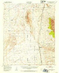
 1948 Chihuahua Ranch1954 Print · USGSLincoln County was a center for military testing and cattle ranching in the late 1940s. Genealogists and researchers can trace family-named sites like Barnes Ranch and Withers Ranch alongside the Oscura Coal Mine (Abandoned).
 - 1948 Map of Mockingbird Gap, 1955 Print
 1948 Mockingbird Gap1955 Print · USGSHigh-desert ranching meets Cold War military testing in this late 1940s survey of the Oscura Mountains. Researchers can trace remote outposts like A D Helm Ranch and Estes City alongside early installations for the White Sands Proving Ground.2 unique versions available
End of results
Showing maps 1-8 of 8
Top cities of Lincoln County
- Ruidoso historical maps
- Alto historical maps
- Ruidoso Downs historical maps
- Capitan historical maps
- Carrizozo historical maps
- Corona historical maps
Frequently asked questions
- What are the different types of historical maps available for Lincoln County?
- What is the oldest map of Lincoln County?
- Where can I purchase historical maps of Lincoln County for my home or office?
- Where can I download high-res historical maps of Lincoln County?
- Are there historical topographic maps available for Lincoln County?
- Is there historical aerial imagery available for Lincoln County?
- Where are historical maps of Lincoln County sourced from?