1990s Maps of Lincoln County, New Mexico
Explore 7 historic maps of Lincoln County from the 1990s. These maps offer a rare glimpse into what life looked like during the 1990s — showing old roads, neighborhoods, homes, and landmarks that have changed or disappeared over time.
Whether you're researching your family's past, planning a metal detecting trip, or studying how Lincoln County's landscape evolved across the 1990s, these high-resolution maps are a powerful tool for exploring the history of this region.
- Focus on a specific era: All maps on this page are from the 1990s, giving you a focused view of this time period.
- See what’s changed: Compare century-old streets, trails, and buildings to today's modern landscape using overlays and satellite layers.
- Research with precision: Use these maps for genealogy, historical research, land use analysis, or educational projects.
- View, download, or print: Maps are fully viewable online in high resolution, and can be downloaded or printed for your own records.
Start exploring Lincoln County's history through authentic maps from the 1990s. This is your window into the past.
Lincoln County, NM maps
(7)- 1995 Map of Cedarvale, 1998 Print
 1995 Cedarvale1998 Print · USGSCentral New Mexico ranching and forest lands are captured in the mid-nineties, showing the intersection of Cedarvale and the Cibola National Forest. Trace family-named sites and water infrastructure like Miller Ranch, Herring Windmill, and Lobo Tank.
 - 1995 Map of Progresso SE, 1998 Print
 1995 Progresso SE1998 Print · USGSThe high desert range and northern Gallinas Mountains are captured here in the mid-1990s as this remote corner of New Mexico remained defined by ranching life. Researchers can trace land use through named water improvements like Bates Ranch, Pruett Well, and Lockey Tank.
 - 1995 Map of Progresso SW, 1998 Print
 1995 Progresso SW1998 Print · USGSHigh desert ranching in Torrance County during the mid-nineties is defined by isolated outposts and vital water improvements. Researchers can locate remote family landmarks like the Atkinson Ranch and trace a network of named wells including Axtell Well and Middle Well.
 - 1995 Map of Tecolote Peak, 1998 Print
 1995 Tecolote Peak1998 Print · USGSHigh-desert ranching and forest land in Lincoln County come into focus in the mid-1990s, when water infrastructure was central to the area's survival. Researchers can trace historic family holdings and survey lines through Vaughn Ranch, Tecolote Peak, and the First Guide Meridian East.
 - 1995 Map of Rough Mountain, 1998 Print
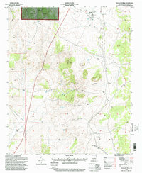
 1995 Rough Mountain1998 Print · USGSLincoln County ranching and mining history intersect in the 1990s as this high-desert landscape undergoes forestry management. Genealogists and researchers can trace family-named outposts like Bryan Ranch and historic mining sites such as the Corona Queen Mine.
 - 1995 Map of Pajaro Canyon, 1998 Print
 1995 Pajaro Canyon1998 Print · USGSThe Gallinas Mountains and the rugged canyons of central New Mexico are captured here during the mid-1990s. Local researchers and genealogists can locate ranching landmarks like Surrat Ranch, the School Section Windmill, and numerous wells such as Youngblood Well.
 - 1995 Map of Corona North, 1998 Print
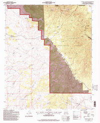
 1995 Corona North1998 Print · USGSHigh-desert ranching and rail history converge in central New Mexico during the 1990s. Researchers can trace family ranching sites like Brunson Ranch and follow the Southern Pacific tracks through Torrance and Corona.
End of results
Showing maps 1-7 of 7
Top cities of Lincoln County
- Ruidoso historical maps
- Alto historical maps
- Ruidoso Downs historical maps
- Capitan historical maps
- Carrizozo historical maps
- Corona historical maps
Frequently asked questions
- What are the different types of historical maps available for Lincoln County?
- What is the oldest map of Lincoln County?
- Where can I purchase historical maps of Lincoln County for my home or office?
- Where can I download high-res historical maps of Lincoln County?
- Are there historical topographic maps available for Lincoln County?
- Is there historical aerial imagery available for Lincoln County?
- Where are historical maps of Lincoln County sourced from?