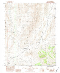
1984 Map of Gold Butte
USGS Topo · Published 1984About this map
The settlement of Gold Butte sits at the heart of this high-desert landscape in Clark County, serving as a hub for the mining and ranching operations that defined this corner of Nevada in the early 1980s. The map documents a rugged interior partitioned by Tramp Ridge and Lime Ridge, with water sources like Perkins Spring and Bills Spring providing critical points of human activity in an otherwise arid environment. Evidence of local industry is clear through the presence of the Lincoln Mine, Black Jack Mine, and Ole Mine, alongside a primitive Landing Strip and numerous guzzlers installed for wildlife or livestock.
Find a feature on this map
28 named features on this map. Tap any name to fly to it.
Don’t see what you’re looking for? This feature index may not catch every label — zoom into the map to look around manually.
Map Details
Editions of this 1984 Gold Butte Map
This is the sole edition of this map. No revisions or reprints were ever made.
Other maps of this area

1886 · Saint Thomas
USGS Topo · 1:250,000

1893 · Saint Thomas
USGS Topo · 1:250,000

1926 · Bonelli
USGS Topo · 1:96,000

1953 · Overton Beach
USGS Topo · 1:62,500

1953 · Iceberg Canyon
USGS Topo · 1:62,500

1953 · Gold Butte
USGS Topo · 1:62,500

1953 · Virgin Basin
USGS Topo · 1:62,500

1954 · Las Vegas
USGS Topo · 1:250,000

1957 · Las Vegas
USGS Topo · 1:250,000

1959 · Las Vegas
USGS Topo · 1:250,000