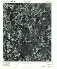
1977 Map of Gold Hill
USGS Topo · Published 1979About this map
Gold Hill and the surrounding Rowan County countryside are captured in this late-1970s orthophotoquad, which uses rectified aerial imagery to show the physical reality of the Piedmont landscape. The settlement of Liberty sits central to a patchwork of agricultural clearings and dense woodlands. To the north, the massive expanse of High Rock Lake dominates the terrain, formed by the impoundment of the Yadkin River. This specific format reveals the exact footprints of farmsteads and the winding courses of waterways like Second Creek as they existed in 1977. Unlike traditional line-drawing maps, this imagery provides genealogists and land researchers with a direct view of historical property boundaries and tree lines that defined the local community during this era.
Find a feature on this map
5 named features on this map. Tap any name to fly to it.
Don’t see what you’re looking for? This feature index may not catch every label — zoom into the map to look around manually.
Map Details
Editions of this 1977 Gold Hill Map
This is the sole edition of this map. No revisions or reprints were ever made.
Other maps of this area

1949 · High Rock
USGS Topo · 1:24,000

1949 · Denton NW
USGS Topo · 1:24,000

1953 · Charlotte
USGS Topo · 1:250,000

1954 · Charlotte
USGS Topo · 1:250,000

1957 · Mount Pleasant
USGS Topo · 1:62,500

1957 · Albemarle
USGS Topo · 1:62,500

1957 · Denton
USGS Topo · 1:62,500

1960 · Charlotte
USGS Topo · 1:250,000

1962 · Charlotte
USGS Topo · 1:250,000

1962 · Southmont
USGS Topo · 1:24,000