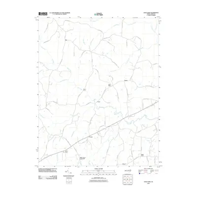
2010 Map of Gold Sand
USGS Topo · Published 2010About this map
Sandy Creek and its many tributaries, including the colorfully named Devils Cradle Creek, carve through this rural section of Franklin County. The landscape is defined by a network of historic crossroads and small communities such as White Level, Gupton, and Alert. Notable landmarks like the White Level Airfield and Highland Memory Gardens suggest the integration of modern infrastructure within a traditionally agrarian setting. This era of the landscape features a dense web of local roads named for prominent residents, such as Duke Valentine Wynne Rd and Alber Gupton Rd, which provide a genealogical roadmap of family landholdings. To the south, Sukey Young Crossroads and the settlement of Oswego mark the transition toward more populated districts, while the northern reaches remain punctuated by small creek crossings like Persons Bridge.
Find a feature on this map
67 named features on this map. Tap any name to fly to it.
Don’t see what you’re looking for? This feature index may not catch every label — zoom into the map to look around manually.
Map Details
Editions of this 2010 Gold Sand Map
This is the sole edition of this map. No revisions or reprints were ever made.
Other maps of this area

1953 · Greensboro
USGS Topo · 1:250,000

1954 · Greensboro
USGS Topo · 1:250,000

1962 · Greensboro
USGS Topo · 1:250,000

1966 · Greensboro
USGS Topo · 1:250,000

1970 · Vicksboro
USGS Topo · 1:24,000

1971 · Inez
USGS Topo · 1:24,000

1971 · Afton
USGS Topo · 1:24,000
1978 · Gold Sand
USGS Topo · 1:24,000
1978 · Louisburg
USGS Topo · 1:24,000
1978 · Centerville
USGS Topo · 1:24,000