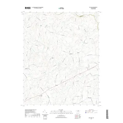
2019 Map of Gold Sand
USGS Topo · Published 2019About this map
Gold Sand and Gupton anchor the heart of this Franklin County landscape, where the headwaters of numerous creeks carve through the North Carolina Piedmont. The rural character of the region is defined by a dense network of secondary roads, many bearing long-standing family names such as Vance Bobbitt Dr, G F Ball Rd, and Sidney Hale Rd. These routes connect dispersed settlements like Alert in the northwest and White Level to the southeast, illustrating a land-use pattern rooted in local agriculture and community hubs. In the northern reaches, the Warren Co and Franklin Co border follows the meandering course of Little Shocco Cr and Shocco Cr. The presence of Highland Memory Gardens and several older settlement sites like Persons Bridge provides vital geographic context for researchers tracing the development of these rural townships in the early 21st century.
Find a feature on this map
84 named features on this map. Tap any name to fly to it.
Don’t see what you’re looking for? This feature index may not catch every label — zoom into the map to look around manually.
Map Details
Editions of this 2019 Gold Sand Map
This is the sole edition of this map. No revisions or reprints were ever made.
Other maps of this area

1953 · Greensboro
USGS Topo · 1:250,000

1954 · Greensboro
USGS Topo · 1:250,000

1962 · Greensboro
USGS Topo · 1:250,000

1966 · Greensboro
USGS Topo · 1:250,000

1970 · Vicksboro
USGS Topo · 1:24,000

1971 · Inez
USGS Topo · 1:24,000

1971 · Afton
USGS Topo · 1:24,000
1978 · Gold Sand
USGS Topo · 1:24,000
1978 · Louisburg
USGS Topo · 1:24,000
1978 · Centerville
USGS Topo · 1:24,000