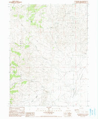
1990 Map of Goldbanks Hills
USGS Topo · Published 1990About this map
Mining activity in the Goldbanks Hills defines this high-desert landscape in Pershing County. Numerous prospects, a mine shaft, and a mine tunnel prospect are scattered across the terrain, most notably an Open Pit Mine (Quick Silver Mine). The drainage network centers on Peavine Creek and Wilder Creek, which flow toward the broad expanses of Grass Valley and Pleasant Valley Creek. The topography is anchored by prominent landmarks such as Table Mountain in the northwest and Squaw Butte near the center. The map also reveals localized features like Coyote Springs and the distinctive bend known as Devils Elbow, reflecting the isolated nature of these hills before modern development altered the surface and drainage patterns of the Great Basin.
Find a feature on this map
24 named features on this map. Tap any name to fly to it.
Don’t see what you’re looking for? This feature index may not catch every label — zoom into the map to look around manually.
Map Details
Editions of this 1990 Goldbanks Hills Map
This is the sole edition of this map. No revisions or reprints were ever made.
Other maps of this area

1932 · Sonoma Range
USGS Topo · 1:250,000

1939 · Sonoma Range
USGS Topo · 1:250,000

1955 · Winnemucca
USGS Topo · 1:250,000

1958 · Winnemucca
USGS Topo · 1:250,000
1961 · Kyle Hot Springs
USGS Topo · 1:62,500

1961 · Mt. Tobin
USGS Topo · 1:62,500

1961 · Leach Hot Springs
USGS Topo · 1:62,500

1961 · Dun Glen
USGS Topo · 1:62,500

1962 · Winnemucca
USGS Topo · 1:250,000

1982 · Fish Creek Mts
USGS Topo · 1:100,000