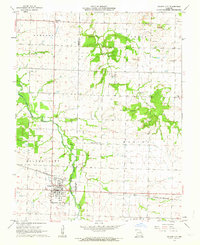
1962 Map of Golden City
USGS Topo · Published 1964About this map
Golden City anchors the southwestern corner of this Barton County landscape, serving as a hub for the St Louis - San Francisco railroad. The grid of the town is remarkably detailed, showing the Harlow-Wright Cem on its southern edge and a nearby Sewage Disposal plant. This era of the Missouri prairie is defined by a mix of traditional agriculture and encroaching industry, evidenced by numerous Strip Mines scattered across the northern sections of Cedar and Newport townships.
Find a feature on this map
19 named features on this map. Tap any name to fly to it.
Don’t see what you’re looking for? This feature index may not catch every label — zoom into the map to look around manually.
Map Details
Editions of this 1962 Golden City Map
This is the sole edition of this map. No revisions or reprints were ever made.
Other maps of this area

1886 · Nevada
USGS Topo · 1:125,000

1886 · Stockton
USGS Topo · 1:125,000

1886 · Greenfield
USGS Topo · 1:125,000

1886 · Carthage
USGS Topo · 1:125,000

1888 · Greenfield
USGS Topo · 1:125,000

1894 · Nevada
USGS Topo · 1:125,000

1894 · Carthage
USGS Topo · 1:125,000

1947 · Joplin
USGS Topo · 1:250,000

1949 · Joplin
USGS Topo · 1:250,000

1954 · Springfield
USGS Topo · 1:250,000