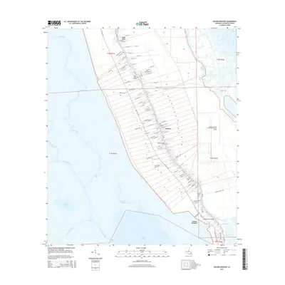
2015 Map of Golden Meadow
USGS Topo · Published 2015About this map
Bayou Lafourche serves as the central spine of this coastal Louisiana landscape, dictating the linear settlement pattern of Galliano and Golden Meadow. The map illustrates the distinctive long-lot land divisions characteristic of French colonial influence, where narrow strips of property extend away from the bayou toward the wetlands. This 2015 survey reveals a community deeply tied to both the water and the air, featuring the South Lafourche Leonard Miller Junior Airport and critical infrastructure like the Golden Meadow Bridge and South Lafourche Bridge. Numerous family burial grounds, including Cheramie Cem, Hebert Cem, and Williams Cem, are situated close to the main thoroughfares, providing valuable data for genealogical research. Beyond the inhabited corridor, the terrain transitions into a complex network of waterways like Bayou Blue and Lake Cheniere, reflecting the precarious geography of the Mississippi River Delta region.
Find a feature on this map
98 named features on this map. Tap any name to fly to it.
Don’t see what you’re looking for? This feature index may not catch every label — zoom into the map to look around manually.
Map Details
Editions of this 2015 Golden Meadow Map
This is the sole edition of this map. No revisions or reprints were ever made.
Other maps of this area

1892 · Barataria
USGS Topo · 1:62,500

1892 · Cut-Off
USGS Topo · 1:62,500

1892 · Creole
USGS Topo · 1:62,500

1894 · Lake Felicity
USGS Topo · 1:62,500

1935 · Viguerie Canal
USGS Topo · 1:31,680

1935 · Bay Courant
USGS Topo · 1:31,680

1935 · Golden Meadow
USGS Topo · 1:31,680

1935 · Mink Bayou
USGS Topo · 1:31,680

1939 · Cut-Off
USGS Topo · 1:62,500

1939 · Lake Felicity
USGS Topo · 1:62,500