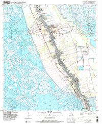
1998 Map of Golden Meadow
USGS Topo · Published 2000About this map
The linear settlement pattern of the Louisiana coast is strikingly visible along Bayou Lafourche, where narrow ribbons of land support a dense corridor of communities including Galliano and Golden Meadow. This 1998 survey illustrates the precarious balance between human habitation and the surrounding wetlands, with an extensive Levee system protecting homes and industry from the encroaching waters of the Pointe Au Chien State Wildlife Management Area and various marshy bayous. The map records a landscape heavily influenced by resource extraction, dominated by the Bully Camp and Gas Field and the Catfish Lake Oil and Gas Field. For genealogists, the map is a vital resource, precisely locating several family-named burial grounds such as Hébert Cem, Cheramie Cem, and Pitre Cem that serve the local parish population.
Find a feature on this map
42 named features on this map. Tap any name to fly to it.
Don’t see what you’re looking for? This feature index may not catch every label — zoom into the map to look around manually.
Map Details
Editions of this 1998 Golden Meadow Map
This is the sole edition of this map. No revisions or reprints were ever made.
Other maps of this area

1892 · Barataria
USGS Topo · 1:62,500

1892 · Cut-Off
USGS Topo · 1:62,500

1892 · Creole
USGS Topo · 1:62,500

1894 · Lake Felicity
USGS Topo · 1:62,500

1935 · Viguerie Canal
USGS Topo · 1:31,680

1935 · Bay Courant
USGS Topo · 1:31,680

1935 · Golden Meadow
USGS Topo · 1:31,680

1935 · Mink Bayou
USGS Topo · 1:31,680

1939 · Cut-Off
USGS Topo · 1:62,500

1939 · Lake Felicity
USGS Topo · 1:62,500