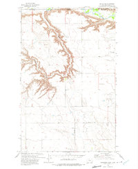
1972 Map of Goldstone
USGS Topo · Published 1975About this map
Milk River and the deeply eroded drainage of Kennedy Coulee dominate this landscape along the international boundary between the Canada United States border. This 1970s survey captures the high plains of northern Hill Co, Montana, where the terrain transitions from the winding river valley to the plateau above. Settlement is sparse, characterized by the remote outpost of Goldstone and the family-named site of Christianson. Genealogists and local historians will find the St Wenceslaus Cem in the northeastern quadrant, a significant landmark in this rural ranching region. The map also delineates the Rudyard Road, the primary terrestrial artery connecting these isolated northern settlements to the larger rail and trade centers further south.
Find a feature on this map
10 named features on this map. Tap any name to fly to it.
Don’t see what you’re looking for? This feature index may not catch every label — zoom into the map to look around manually.
Map Details
Editions of this 1972 Goldstone Map
This is the sole edition of this map. No revisions or reprints were ever made.
Other maps of this area

1919 · Alma
USGS Topo · 1:125,000

1920 · Gildford
USGS Topo · 1:125,000

1943 · Gildford
USGS Topo · 1:125,000

1954 · Shelby
USGS Topo · 1:250,000

1958 · Shelby
USGS Topo · 1:250,000

1972 · Goldstone SW
USGS Topo · 1:24,000

1972 · Mc Kinnsey Reservoir East
USGS Topo · 1:24,000

1972 · Mc Kinnsey Reservoir West
USGS Topo · 1:24,000
1972 · Lost River
USGS Topo · 1:24,000
1972 · Laird Lake
USGS Topo · 1:24,000