
1957 Map of Gonzales
USGS Topo · Published 1966About this map
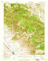
The Gabilan Range dominates this mid-century survey, dividing the landscape between the agricultural Salinas Valley and the rugged interior of the Cienega Del Gabilan. In the valley floor, the town of Gonzales serves as a hub for the surrounding ranchlands, situated along the Southern Pacific railroad and U.S. 101. Rural life is marked by the presence of the Cienega School and numerous land grants, including Rincon De La Puente Del Monte and Encinal Y Buena Esperanza. To the east, the San Benito River flows past Paicines Ranch and the Paicines Reservoir, while the upland terrain is dotted with small-scale industrial activity such as a quarry near Mt Harlan. Notable summits like McPhails Peak and Mt Johnson tower over a complex network of canyons, including Chualar Canyon and Johnson Canyon, which channel drainage toward the valley settlements.
Find a feature on this map
68 named features on this map. Tap any name to fly to it.
Don’t see what you’re looking for? This feature index may not catch every label — zoom into the map to look around manually.
Map Details
Editions of this 1957 Gonzales Map
2 editions found
Other maps of this area

1910 · Gonzales
USGS Topo · 1:31,680

1910 · Salinas
USGS Topo · 1:31,680

1910 · Soledad
USGS Topo · 1:31,680

1912 · Salinas
USGS Topo · 1:62,500

1915 · Soledad
USGS Topo · 1:62,500

1915 · San Juan Bautista
USGS Topo · 1:48,000

1917 · San Juan Bautista
USGS Topo · 1:62,500

1919 · San Benito
USGS Topo · 1:62,500

1919 · Hollister
USGS Topo · 1:48,000

1920 · Jamesburg
USGS Topo · 1:48,000