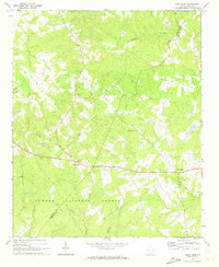
1971 Map of Good Hope
USGS Topo · Published 1973About this map
Sumter National Forest dominates the southern landscape of this 1971 survey, where the rolling woodlands of the South Carolina Piedmont are etched by several drainage systems. Small rural communities like Good Hope and Cambridge serve as local anchors, connected by a network of state routes and unimproved roads that trace the high ground between creek beds. The map captures a transition in land use, showing several claypits and the dispersed nature of local social centers, which are primarily identified by their small country churches.
Find a feature on this map
25 named features on this map. Tap any name to fly to it.
Don’t see what you’re looking for? This feature index may not catch every label — zoom into the map to look around manually.
Map Details
Editions of this 1971 Good Hope Map
This is the sole edition of this map. No revisions or reprints were ever made.
Other maps of this area

1892 · Mc Cormick
USGS Topo · 1:125,000

1892 · Abbeville
USGS Topo · 1:125,000

1908 · Kirksey
USGS Topo · 1:24,000

1912 · Mc Cormick
USGS Topo · 1:125,000

1941 · Spartanburg
USGS Topo · 1:250,000

1949 · Ninety-Six
USGS Topo · 1:24,000

1950 · Kirksey
USGS Topo · 1:24,000

1953 · Athens
USGS Topo · 1:250,000

1953 · Spartanburg
USGS Topo · 1:250,000

1954 · Augusta
USGS Topo · 1:250,000