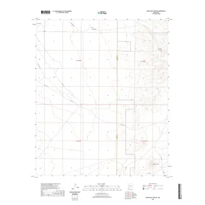
2020 Map of Good Sight Peak NE
USGS Topo · Published 2020About this map
Sierra de las Uvas dominates the eastern portion of this high-desert landscape, creating a dramatic topographical contrast against the flatter terrain to the west. This area on the boundary of Luna and Doña Ana counties is crossed by the historic Butterfield Trl, a route deeply tied to the expansion of mail and passenger transit in the American West. The presence of Massacre Peak in the southeast corner provides a landmark for those studying the region's complex frontier history and early surveying efforts. Water resources are scarce in this arid environment, making features like Howard Tank critical points of interest for livestock management and early transit. Rural roads such as Cattlemen Rd NE and Uvas Valley Rd NE indicate the continued use of this land for ranching, while Pine Canyon offers one of the few named topographical breaks in the northern reach.
Find a feature on this map
19 named features on this map. Tap any name to fly to it.
Don’t see what you’re looking for? This feature index may not catch every label — zoom into the map to look around manually.
Map Details
Editions of this 2020 Good Sight Peak NE Map
This is the sole edition of this map. No revisions or reprints were ever made.
Other maps of this area

1943 · Corralitos Ranch
USGS Topo · 1:62,500

1955 · Las Cruces
USGS Topo · 1:250,000

1958 · Las Cruces
USGS Topo · 1:250,000
1959 · Souse Springs
USGS Topo · 1:24,000

1961 · Nutt
USGS Topo · 1:62,500

1972 · Myndus
USGS Topo · 1:24,000

1972 · Good Sight Peak NE
USGS Topo · 1:24,000

1972 · Good Sight Peak
USGS Topo · 1:24,000

1972 · Lazy E Ranch
USGS Topo · 1:24,000

1982 · Hatch
USGS Topo · 1:100,000