
1972 Map of Lazy E Ranch
USGS Topo · Published 1975About this map
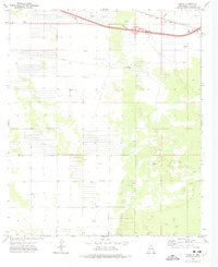
The Good Sight Mountains dominate this arid landscape, a region defined by the critical infrastructure of ranching and remote navigation in the early 1970s. This survey focuses on the rugged boundary between Luna County and Doña Ana County, where the Lazy E Ranch serves as the primary hub of human activity. The map reveals an intricate network of water management essential for survival in this high-desert environment, documented through numerous family and place-named wells such as Matamoros Windmill, Suman Windmill, and Dog Town Windmill. A remote Landing Strip and various Jeep Trails suggest the logistical challenges of accessing these uplands. Beyond the ranching operations, the landscape is marked by industrial remnants like a Gravel Pit, providing a detailed view of how this borderland was utilized before modern expansion.
Find a feature on this map
17 named features on this map. Tap any name to fly to it.
Don’t see what you’re looking for? This feature index may not catch every label — zoom into the map to look around manually.
Map Details
Editions of this 1972 Lazy E Ranch Map
This is the sole edition of this map. No revisions or reprints were ever made.
Other maps of this area

1941 · Aden
USGS Topo · 1:62,500

1943 · Aden
USGS Topo · 1:62,500

1943 · Corralitos Ranch
USGS Topo · 1:62,500

1955 · Las Cruces
USGS Topo · 1:250,000

1958 · Las Cruces
USGS Topo · 1:250,000

1972 · Myndus
USGS Topo · 1:24,000

1972 · Cambray
USGS Topo · 1:24,000

1972 · Good Sight Peak NE
USGS Topo · 1:24,000

1972 · Good Sight Peak
USGS Topo · 1:24,000
1972 · Akela
USGS Topo · 1:24,000