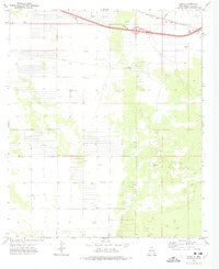
1972 Map of Akela
USGS Topo · Published 1975About this map
Akela stands as a lonely outpost in the high desert of Luna County, centered around a critical junction of transport and infrastructure in the early 1970s. The landscape of Akela Flats is defined by the parallel paths of the Southern Pacific railroad and the modern Akela Interchange, reflecting a mid-century shift from rail-dependent commerce to interstate travel. This survey meticulously documents the region's industrial and agricultural utility, from the Florida Pumping Sta and various pipelines to the numerous drill holes and borrow pits scattered across the arid terrain. Local landmarks such as the Matamoros Windmill and a solitary Radio Tower provide rare vertical relief in an otherwise flat expanse dedicated to resource extraction and transit.
Find a feature on this map
15 named features on this map. Tap any name to fly to it.
Don’t see what you’re looking for? This feature index may not catch every label — zoom into the map to look around manually.
Map Details
Editions of this 1972 Akela Map
This is the sole edition of this map. No revisions or reprints were ever made.
Other maps of this area

1899 · Deming
USGS Topo · 1:125,000

1915 · Deming
USGS Topo · 1:125,000

1955 · Las Cruces
USGS Topo · 1:250,000

1958 · Las Cruces
USGS Topo · 1:250,000

1964 · Gym Peak
USGS Topo · 1:24,000

1964 · Florida Gap
USGS Topo · 1:24,000

1965 · Carne
USGS Topo · 1:24,000

1972 · Myndus
USGS Topo · 1:24,000

1972 · Cambray
USGS Topo · 1:24,000
1972 · X-7 Ranch
USGS Topo · 1:24,000