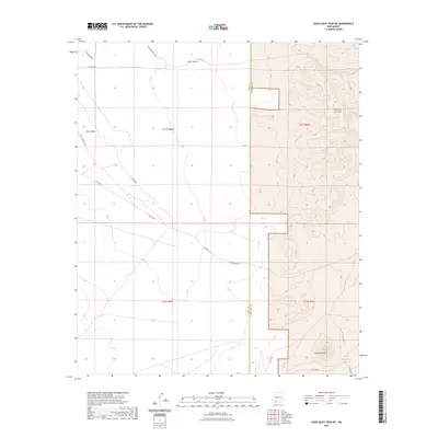
2023 Map of Good Sight Peak NE
USGS Topo · Published 2023About this map
Butterfield Trl cuts across this high desert landscape, tracing a historic path through the southwestern frontier where the Luna and Doña Ana county line meets. The terrain is defined by the sharp rise of the Sierra de las Uvas to the east and the isolated prominence of Massacre Peak to the south. This 2023 survey illustrates a region largely shaped by its hydrology and ranching infrastructure, featuring catchments like Howard Tank and the deep drainage of Pine Canyon. While the Uvas Valley provides relatively level ground, it is flanked by complex ridgelines. A network of rural routes, including Cattlemen Rd Ne and Saddle Bag Rd, provides the modern framework for accessing this arid corridor between the county boundaries.
Find a feature on this map
20 named features on this map. Tap any name to fly to it.
Don’t see what you’re looking for? This feature index may not catch every label — zoom into the map to look around manually.
Map Details
Editions of this 2023 Good Sight Peak NE Map
This is the sole edition of this map. No revisions or reprints were ever made.
Other maps of this area

1943 · Corralitos Ranch
USGS Topo · 1:62,500

1955 · Las Cruces
USGS Topo · 1:250,000

1958 · Las Cruces
USGS Topo · 1:250,000
1959 · Souse Springs
USGS Topo · 1:24,000

1961 · Nutt
USGS Topo · 1:62,500

1972 · Myndus
USGS Topo · 1:24,000

1972 · Good Sight Peak NE
USGS Topo · 1:24,000

1972 · Good Sight Peak
USGS Topo · 1:24,000

1972 · Lazy E Ranch
USGS Topo · 1:24,000

1982 · Hatch
USGS Topo · 1:100,000