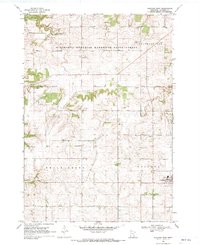
1968 Map of Goodhue West
USGS Topo · Published 1970About this map
The Minnesota Memorial Hardwood State Forest blankets the northern bluffs of this Goodhue County landscape, where the terrain breaks into deep coulees and wooded ridges. In the late 1960s, the rural character of the region is defined by a dense network of homesteads and social centers like the Townhall near Ryan. The transition from agrarian upland to the lowlands of Hay Creek reveals a history of land use marked by numerous quarries and gravel pits, reflecting the local mineral economy. Religious life is well-documented through several country churches and burial grounds, including St Columbkille Ch and the Zion Ch Cem. To the east, an Old Railroad Grade indicates a shifting transportation landscape near the settlement of Claybank, while the village of Goodhue serves as a concentrated hub at the edge of the survey area.
Find a feature on this map
21 named features on this map. Tap any name to fly to it.
Don’t see what you’re looking for? This feature index may not catch every label — zoom into the map to look around manually.
Map Details
Editions of this 1968 Goodhue West Map
This is the sole edition of this map. No revisions or reprints were ever made.
Other maps of this area

1944 · Red Wing
USGS Topo · 1:62,500

1952 · Red Wing
USGS Topo · 1:62,500

1953 · Saint Paul
USGS Topo · 1:250,000

1957 · Hastings
USGS Topo · 1:62,500

1959 · Saint Paul
USGS Topo · 1:250,000

1968 · Goodhue East
USGS Topo · 1:24,000

1968 · Zumbrota
USGS Topo · 1:24,000

1968 · Mazeppa
USGS Topo · 1:24,000

1968 · Wanamingo
USGS Topo · 1:24,000

1968 · White Rock
USGS Topo · 1:24,000