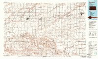
1985 Map of Goodland
USGS Topo · Published 1988About this map
Goodland serves as the primary hub in this mid-1980s look at Northwest Kansas, where the High Plains are defined by the straight lines of the Union Pacific railroad and Interstate 70. This survey captures a landscape transition where the flat upland grain fields are deeply incised by the drainage systems of the Smoky Hill River and the South Fork Solomon River. Small rail-aligned settlements like Ruleton, Edson, and Brewster dot the corridor, each reflecting the region’s agricultural dependence and the importance of transit links to larger centers like Colby. Local aviation is well-represented through numerous rural facilities, including Renner Field and several private landing strips such as the Lowe Landing Strip. The map also details the township structure, including Voltaire and Itasca, providing a precise grid for those researching land ownership and genealogy in Sherman, Thomas, and Wallace counties during the late twentieth century.
Find a feature on this map
75 named features on this map. Tap any name to fly to it.
Don’t see what you’re looking for? This feature index may not catch every label — zoom into the map to look around manually.
Map Details
Editions of this 1985 Goodland Map
2 editions found
Other maps of this area

1892 · Cheyenne Wells
USGS Topo · 1:125,000

1894 · Cheyenne Wells
USGS Topo · 1:125,000

1943 · Colby
USGS Topo · 1:62,500

1950 · Bonny Reservoir
USGS Topo · 1:62,500

1951 · Bird City South
USGS Topo · 1:62,500

1951 · Achilles
USGS Topo · 1:62,500

1951 · Chardon
USGS Topo · 1:62,500

1951 · Dewey Ranch
USGS Topo · 1:62,500

1952 · St Francis 3
USGS Topo · 1:62,500

1954 · Limon
USGS Topo · 1:250,000