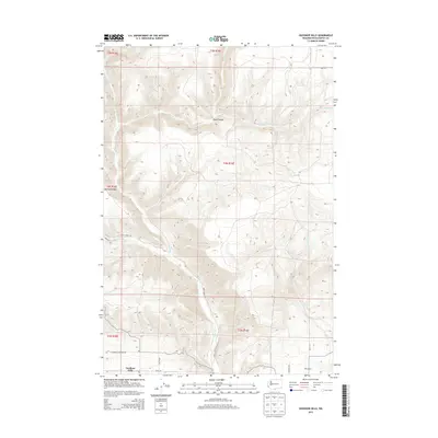
2013 Map of Goodnoe Hills
USGS Topo · Published 2013About this map
Goodnoe Hills occupies the high ground of Klickitat County in this early 21st-century landscape, where deep drainages like Glass Canyon and Harrison Ridge define the local topography. The area is characterized by a sparse network of rural roads, including Chamberlin Goodnoe Rd and Imrie Rd, which navigate the elevation changes between the hills and the southern plains. Water is a central element of the terrain, with Rock Creek carving a significant path through the center of the sheet, joined by smaller tributaries like Squaw Creek and White Creek. The presence of The Burn in the southeast corner provides a record of the region's environmental history, while the proximity of the Harrison Creek headwaters underscores the importance of natural drainage patterns in this corner of Washington.
Find a feature on this map
23 named features on this map. Tap any name to fly to it.
Don’t see what you’re looking for? This feature index may not catch every label — zoom into the map to look around manually.
Map Details
Editions of this 2013 Goodnoe Hills Map
This is the sole edition of this map. No revisions or reprints were ever made.
Other maps of this area

1916 · Arlington
USGS Topo · 1:125,000

1953 · The Dalles
USGS Topo · 1:250,000

1956 · The Dalles
USGS Topo · 1:250,000

1957 · The Dalles
USGS Topo · 1:250,000

1957 · Wasco
USGS Topo · 1:62,500

1957 · Satus Pass
USGS Topo · 1:62,500

1965 · Goodnoe Hills
USGS Topo · 1:24,000
1965 · Bickleton
USGS Topo · 1:24,000
1965 · Dot
USGS Topo · 1:24,000
1965 · Bickleton NW
USGS Topo · 1:24,000