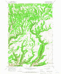
1965 Map of Bickleton NW
USGS Topo · Published 1967About this map
Bickleton Ridge dominates this mid-1960s landscape, where the Indian Reservation Bdy cuts across the northern terrain. This is a region defined by its deep drainage networks and isolated water sources, essential for the ranching operations that utilized the land. Named canyons and gulches like Milk Ranch Canyon and Wood Gulch provide natural corridors through the high country. Evidence of local habitation and land use is sparse but specific, marked by the presence of a Storage Bin near Gadeberg Rd and a Gravel Pit to the west. Numerous springs, including Milk Ranch Spring, are scattered throughout the draws of Dairy Creek and Squaw Creek, indicating the critical role of water management in this high-altitude Klickitat County environment.
Find a feature on this map
15 named features on this map. Tap any name to fly to it.
Don’t see what you’re looking for? This feature index may not catch every label — zoom into the map to look around manually.
Map Details
Editions of this 1965 Bickleton NW Map
This is the sole edition of this map. No revisions or reprints were ever made.
Other maps of this area

1910 · Zillah
USGS Topo · 1:125,000

1916 · Arlington
USGS Topo · 1:125,000

1937 · White Swan
USGS Topo · 1:125,000

1950 · Yakima
USGS Topo · 1:250,000

1953 · The Dalles
USGS Topo · 1:250,000

1956 · The Dalles
USGS Topo · 1:250,000

1957 · The Dalles
USGS Topo · 1:250,000

1957 · Satus Pass
USGS Topo · 1:62,500

1958 · Yakima
USGS Topo · 1:250,000

1961 · Yakima
USGS Topo · 1:250,000