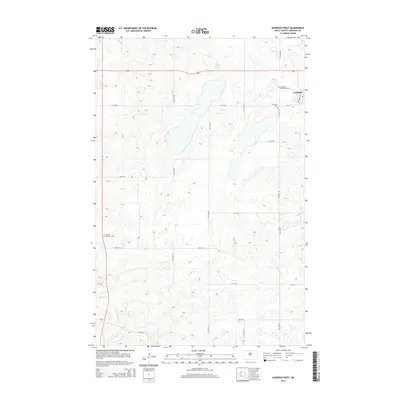
2014 Map of Goodrich West
USGS Topo · Published 2014About this map
Goodrich serves as the primary settlement on this Sheridan County landscape, where the prairie is defined by a rhythmic grid of sectional roads and scattered wetland depressions. The town's local history is anchored by its community sites, specifically the Goodrich Cem and the Goodrich Adventist Cem located on the eastern edge of the survey area. Further west, the Denhoff Adventist Cem sits as a solitary landmark among the section lines, indicating the reach of earlier settler communities. This 2014 survey documents the enduring agricultural layout of the region, where north-south routes like 16th Ave NE and 19th Ave SE connect isolated farmsteads across the undulating North Dakota terrain.
Find a feature on this map
23 named features on this map. Tap any name to fly to it.
Don’t see what you’re looking for? This feature index may not catch every label — zoom into the map to look around manually.
Map Details
Editions of this 2014 Goodrich West Map
This is the sole edition of this map. No revisions or reprints were ever made.
Other maps of this area

1946 · Sheyenne Lake
USGS Topo · 1:48,000

1947 · Lincoln Valley
USGS Topo · 1:62,500

1947 · Sheyenne Lake
USGS Topo · 1:62,500

1954 · McClusky
USGS Topo · 1:250,000

1958 · McClusky
USGS Topo · 1:250,000

1960 · Lincoln Valley SE
USGS Topo · 1:24,000

1960 · Florence Lake
USGS Topo · 1:24,000

1960 · Denhoff
USGS Topo · 1:24,000
1978 · Mertz Slough
USGS Topo · 1:24,000
1978 · Pony Gulch
USGS Topo · 1:24,000