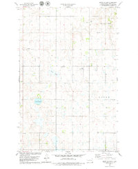
1978 Map of Mertz Slough
USGS Topo · Published 1979About this map
Fairview and Boone townships define the high plains of Sheridan County in this late-1970s landscape, where the prairie is dotted with glacial wetlands and small-scale infrastructure. The terrain is dominated by the namesake Mertz Slough and the nearby Jones Lake, while the local economy is evidenced by scattered Gravel Pits and the presence of the Frueh Landing Field. Genealogists and local historians can pinpoint the exact locations of the Fairview Cem and St James Cem, which serve as vital landmarks for the rural community. The map also delineates the northern reaches of Denhoff and Goodrich townships, showing a transition toward the southern agricultural centers. This survey is particularly useful for observing the intricate network of field lines and section roads that structured North Dakota farming during this era.
Find a feature on this map
11 named features on this map. Tap any name to fly to it.
Don’t see what you’re looking for? This feature index may not catch every label — zoom into the map to look around manually.
Map Details
Editions of this 1978 Mertz Slough Map
This is the sole edition of this map. No revisions or reprints were ever made.
Other maps of this area

1946 · Sheyenne Lake
USGS Topo · 1:48,000

1947 · Lincoln Valley
USGS Topo · 1:62,500

1947 · Sheyenne Lake
USGS Topo · 1:62,500

1950 · Sheyenne Lake NE
USGS Topo · 1:24,000

1950 · Sheyenne Lake
USGS Topo · 1:24,000

1954 · McClusky
USGS Topo · 1:250,000

1958 · McClusky
USGS Topo · 1:250,000

1960 · Lincoln Valley SE
USGS Topo · 1:24,000

1960 · Denhoff
USGS Topo · 1:24,000
1960 · Lincoln Valley
USGS Topo · 1:24,000