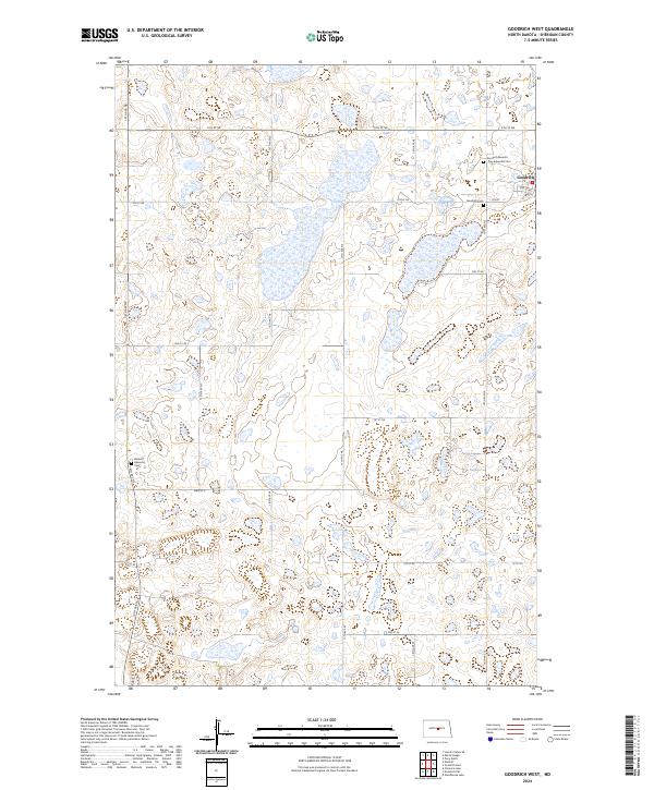
2024 Map of Goodrich West
USGS Topo · Published 2024About this map
Goodrich sits at the western edge of Sheridan County, serving as the primary hub of this prairie landscape characterized by its distinctive township and range grid. The area is defined by a dense network of country roads such as 14th Ave NE and 5th St NE that connect scattered farmsteads across the undulating terrain. A significant genealogical record is preserved here through several burial grounds, including the Goodrich Cem, the Goodrich Seventh Day Adventist Cem, and the Denhoff Adventist Cem located further west. These sites, along with the layout of Main St E, reflect the enduring settlement patterns and religious history of the North Dakota plains in the modern era.
Find a feature on this map
29 named features on this map. Tap any name to fly to it.
Don’t see what you’re looking for? This feature index may not catch every label — zoom into the map to look around manually.
Map Details
Editions of this 2024 Goodrich West Map
This is the sole edition of this map. No revisions or reprints were ever made.
Other maps of this area

1946 · Sheyenne Lake
USGS Topo · 1:48,000

1947 · Lincoln Valley
USGS Topo · 1:62,500

1947 · Sheyenne Lake
USGS Topo · 1:62,500

1954 · McClusky
USGS Topo · 1:250,000

1958 · McClusky
USGS Topo · 1:250,000

1960 · Lincoln Valley SE
USGS Topo · 1:24,000

1960 · Florence Lake
USGS Topo · 1:24,000

1960 · Denhoff
USGS Topo · 1:24,000
1978 · Mertz Slough
USGS Topo · 1:24,000
1978 · Pony Gulch
USGS Topo · 1:24,000