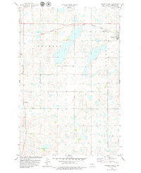
1978 Map of Goodrich West
USGS Topo · Published 1979About this map
Glacial potholes and prairie wetlands define the landscape of Sheridan County in the late 1970s, where the Burlington Northern railroad cuts through the northern plains. The small town of Goodrich serves as the local hub, situated near several community burial grounds including the Goodrich Cem and the Goodrich Adventist Cem. Further west, the Denhoff Adventist Cem sits isolated in the open terrain of the Denhoff township area. This survey reveals a sparsely populated agricultural region where township boundaries like Goodrich and Mauch organize the land. The presence of a prominent Radio Tower indicates the intersection of rural life with modern telecommunications during this period of North Dakota's history.
Find a feature on this map
10 named features on this map. Tap any name to fly to it.
Don’t see what you’re looking for? This feature index may not catch every label — zoom into the map to look around manually.
Map Details
Editions of this 1978 Goodrich West Map
This is the sole edition of this map. No revisions or reprints were ever made.
Other maps of this area

1946 · Sheyenne Lake
USGS Topo · 1:48,000

1947 · Lincoln Valley
USGS Topo · 1:62,500

1947 · Sheyenne Lake
USGS Topo · 1:62,500

1954 · McClusky
USGS Topo · 1:250,000

1958 · McClusky
USGS Topo · 1:250,000

1960 · Lincoln Valley SE
USGS Topo · 1:24,000

1960 · Florence Lake
USGS Topo · 1:24,000

1960 · Denhoff
USGS Topo · 1:24,000
1978 · Mertz Slough
USGS Topo · 1:24,000
1978 · Pony Gulch
USGS Topo · 1:24,000