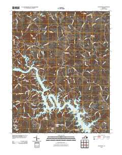
2010 Map of Goodview
USGS Topo · Published 2010About this map
The waters of Smith Mountain Lake dominate this landscape, where the rising shoreline has created numerous peninsulas and coves near Beechwood Shores. The rugged topography of Mead Mountain and Board Mountain defines the northern reaches, giving way to a network of creeks like Stony Creek and Hales Creek that feed into the larger reservoir. This 2010 survey reveals a countryside deeply connected to its past through many family-named burial grounds, including the Basham Cemetery, Ellis Cemetery, and Aylor Cemetery. Traditional landmarks like Carters Island Ford and Turners Ford remain noted on the map, preserving the memory of historical river crossings before modern infrastructure. The community of Goodview sits west of the lake's complex inlets, while Hales Ford Bridge serves as a critical connection over the water, linking the scattered settlements and residential developments that have grown along the lake's edge.
Find a feature on this map
102 named features on this map. Tap any name to fly to it.
Don’t see what you’re looking for? This feature index may not catch every label — zoom into the map to look around manually.
Map Details
Editions of this 2010 Goodview Map
This is the sole edition of this map. No revisions or reprints were ever made.
Other maps of this area

1890 · Roanoke
USGS Topo · 1:125,000

1891 · Roanoke
USGS Topo · 1:125,000

1929 · Roanoke
USGS Topo · 1:48,000

1933 · Roanoke
USGS Topo · 1:62,500

1947 · Roanoke
USGS Topo · 1:250,000

1950 · Peaks of Otter
USGS Topo · 1:62,500

1951 · Boones Mill
USGS Topo · 1:62,500

1951 · Moneta
USGS Topo · 1:62,500

1959 · Roanoke
USGS Topo · 1:250,000

1963 · Roanoke
USGS Topo · 1:250,000