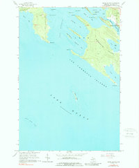
1964 Map of Goose Island
USGS Topo · Published 1989About this map
Les Cheneaux Islands emerge from the northern reaches of Lake Huron in this mid-1960s study, showcasing a complex maritime landscape of sheltered bays and narrow channels. The map focuses on the large landmass of Clark Marquette Island, where high ground is punctuated by Duck Bay and Voight Bay. On the northeastern corner of the island, the small settlement at Patrick Landing and the Edgewood Cem provide a human footprint near the navigable Les Cheneaux Channel.
Find a feature on this map
36 named features on this map. Tap any name to fly to it.
Don’t see what you’re looking for? This feature index may not catch every label — zoom into the map to look around manually.
Map Details
Editions of this 1964 Goose Island Map
2 editions found
Other maps of this area

1931 · Pickford SE
USGS Topo · 1:31,680

1932 · St Ignace NE
USGS Topo · 1:31,680

1954 · Sault Sainte Marie
USGS Topo · 1:250,000

1955 · Cheboygan
USGS Topo · 1:250,000

1956 · Sault Sainte Marie
USGS Topo · 1:250,000

1957 · Sault Sainte Marie
USGS Topo · 1:250,000

1958 · Cheboygan
USGS Topo · 1:250,000

1958 · Sault Sainte Marie
USGS Topo · 1:250,000

1964 · Round Island
USGS Topo · 1:24,000
1964 · Pickford SE
USGS Topo · 1:24,000