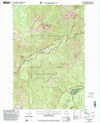
2000 Map of Goose Prairie
USGS Topo · Published 2001About this map
The settlement of Goose Prairie sits at the confluence of mountain waters where the Bumping River meets Thunder Creek, surrounded by the high-elevation protected lands of the William O Douglas Wilderness. This 2000 revision, updated by the Forest Service, captures a landscape defined by seasonal recreation and conservation. Several campgrounds, including Hells Crossing Campground and Pleasant Valley Campground, follow the corridor of the American River, which cuts a deep valley through the Mt Baker Snoqualmie National Forest.
Find a feature on this map
44 named features on this map. Tap any name to fly to it.
Don’t see what you’re looking for? This feature index may not catch every label — zoom into the map to look around manually.
Map Details
Editions of this 2000 Goose Prairie Map
This is the sole edition of this map. No revisions or reprints were ever made.
Other maps of this area

1901 · Snoqualmie Pass
USGS Topo · 1:125,000

1902 · Mount Aix
USGS Topo · 1:125,000

1903 · Snoqualmie
USGS Topo · 1:125,000

1904 · Mt Aix
USGS Topo · 1:125,000

1950 · Yakima
USGS Topo · 1:250,000

1957 · Wenatchee
USGS Topo · 1:250,000

1958 · Yakima
USGS Topo · 1:250,000

1961 · Yakima
USGS Topo · 1:250,000

1961 · Easton
USGS Topo · 1:62,500

1962 · Bumping Lake
USGS Topo · 1:62,500