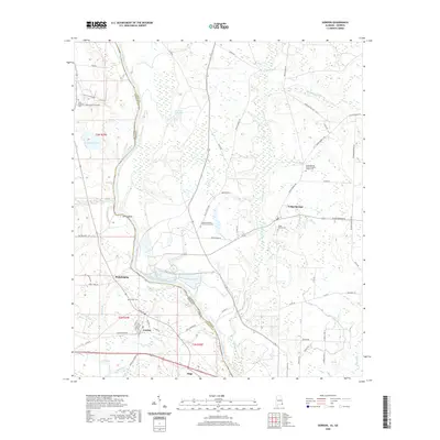
2020 Map of Gordon
USGS Topo · Published 2020About this map
The Chattahoochee River defines the winding border between Houston County, Alabama, and Early County, Georgia, serving as the central artery for this river-bottom landscape. On the Alabama side, the town of Gordon is the primary hub, surrounded by smaller communities such as Philadelphia and Alaga. The terrain is characterized by intricate water networks including Cedar Creek and Howards Mill Cr, alongside family-named landmarks like Smith Bend and Howells Fishpond. Across the water in Georgia, the settlement of Cedar Springs is notable for its cluster of community landmarks, including the Cedar Springs Cem and the Cedar Springs Freewill Baptist Church Cem. The map reveals a deeply rooted rural infrastructure of cemeteries and small churches, such as Saint Stephens Cem and the Liberty Assembly of God Church Cem, reflecting the generations of families who settled these fertile floodplains.
Find a feature on this map
62 named features on this map. Tap any name to fly to it.
Don’t see what you’re looking for? This feature index may not catch every label — zoom into the map to look around manually.
Map Details
Editions of this 2020 Gordon Map
This is the sole edition of this map. No revisions or reprints were ever made.
Other maps of this area

1953 · Dothan
USGS Topo · 1:250,000

1954 · Dothan
USGS Topo · 1:250,000

1955 · Dothan
USGS Topo · 1:250,000

1970 · Gordon
USGS Topo · 1:24,000
1970 · Saffold
USGS Topo · 1:24,000

1970 · Sigma
USGS Topo · 1:24,000

1970 · Columbia
USGS Topo · 1:24,000
1970 · Grangeburg
USGS Topo · 1:24,000
1970 · Ashford
USGS Topo · 1:24,000

1973 · Blakely South
USGS Topo · 1:24,000