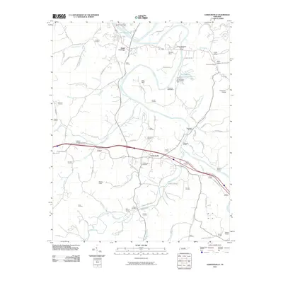
2010 Map of Gordonsville
USGS Topo · Published 2010About this map
The Cumberland River and Caney Fork define the landscape of this Middle Tennessee region, converging near South Carthage and Old Hickory Lake. The terrain is marked by dramatic river bends such as Boulton Bend and Hell Bend, alongside distinctive heights like Winfree Knob. Industrial and infrastructure development is evident through the Jersey Miniery Zinc Company Dam, which created the Jersey Miniery Zinc Company Lake, and major crossings like the Benton McMillian Memorial Bridge. For genealogists, the map is a dense record of family history, naming over twenty burial grounds including the Coffee Cemetery, Gordonsville Cemetery, and Waggoner Cemetery. Local commerce centers around the Gordonsville Post Office and Elmwood Post Office, while the surrounding hollows like Trousdale Hollow and Condit Hollow preserve the names of early settler families.
Find a feature on this map
104 named features on this map. Tap any name to fly to it.
Don’t see what you’re looking for? This feature index may not catch every label — zoom into the map to look around manually.
Map Details
Editions of this 2010 Gordonsville Map
This is the sole edition of this map. No revisions or reprints were ever made.
Other maps of this area

1928 · Gordonsville
USGS Topo · 1:62,500

1932 · Carthage
USGS Topo · 1:62,500

1942 · Statesville
USGS Topo · 1:100,000

1956 · Corbin
USGS Topo · 1:250,000

1956 · Nashville
USGS Topo · 1:250,000

1958 · New Middleton
USGS Topo · 1:24,000

1958 · Corbin
USGS Topo · 1:250,000

1958 · Dixon Springs
USGS Topo · 1:24,000
1958 · Alexandria
USGS Topo · 1:24,000

1959 · Nashville
USGS Topo · 1:250,000