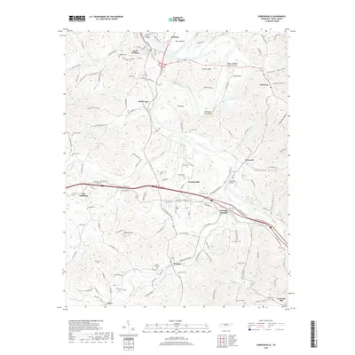
2019 Map of Gordonsville
USGS Topo · Published 2019About this map
The Cumberland River and Caney Fork converge near Carthage and South Carthage, anchoring a landscape defined by sharp river bends and deep hollows. The confluence of these major waterways is marked by significant crossings including the Cordell Hull Bridge and the Benton McMillian Memorial Bridge. Moving south through Gordonsville and Hickman, the terrain rises toward Winfree Knob, while the industrial footprint is visible at the Jersey Miniery Zinc Company Lake. This area of Smith County is densely populated with family and community landmarks, such as Baird Memorial Cem, Gwaltney Cem, and Ducktown Cem. The transportation network is a mix of older routes like Trousdale Ferry Pike and modern corridors, connecting smaller settlements like Old Middleton and Stonewall to the regional river-and-rail centers.
Find a feature on this map
156 named features on this map. Tap any name to fly to it.
Don’t see what you’re looking for? This feature index may not catch every label — zoom into the map to look around manually.
Map Details
Editions of this 2019 Gordonsville Map
This is the sole edition of this map. No revisions or reprints were ever made.
Other maps of this area

1928 · Gordonsville
USGS Topo · 1:62,500

1932 · Carthage
USGS Topo · 1:62,500

1942 · Statesville
USGS Topo · 1:100,000

1956 · Corbin
USGS Topo · 1:250,000

1956 · Nashville
USGS Topo · 1:250,000

1958 · New Middleton
USGS Topo · 1:24,000

1958 · Corbin
USGS Topo · 1:250,000

1958 · Dixon Springs
USGS Topo · 1:24,000
1958 · Alexandria
USGS Topo · 1:24,000

1959 · Nashville
USGS Topo · 1:250,000