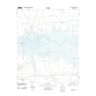
2012 Map of Gore Springs
USGS Topo · Published 2012About this map
Grenada Lake dominates the central landscape of this Mississippi region, where the Yalobusha River flows into the reservoir. The topography is defined by numerous creek systems, including Youngs Cr, Butputter Cr, and Little Horse Pen Cr, which drain the surrounding woodlands into the lake. The settlement pattern is largely rural, clustered around small communities like Gore Springs and Susie in the south, and Youngs and Graysport further north.
Find a feature on this map
79 named features on this map. Tap any name to fly to it.
Don’t see what you’re looking for? This feature index may not catch every label — zoom into the map to look around manually.
Map Details
Editions of this 2012 Gore Springs Map
This is the sole edition of this map. No revisions or reprints were ever made.
Other maps of this area

1953 · Walthall
USGS Topo · 1:62,500

1953 · West Point
USGS Topo · 1:250,000

1954 · Pittsboro
USGS Topo · 1:62,500

1954 · Duck Hill
USGS Topo · 1:62,500

1955 · Coffeeville
USGS Topo · 1:62,500

1958 · West Point
USGS Topo · 1:250,000

1963 · West Point
USGS Topo · 1:250,000
1971 · Coffeeville
USGS Topo · 1:24,000
1983 · Duck Hill
USGS Topo · 1:24,000
1983 · Cadaretta
USGS Topo · 1:24,000