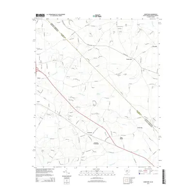
2014 Map of Goretown
USGS Topo · Published 2014About this map
Goretown and Grahams Crossroads sit at the center of this rural Horry County landscape, where the border between South Carolina and North Carolina cuts through the swampy lowlands of the Coastal Plain. The area is defined by an intricate network of wetlands, including the broad reaches of Juniper Swamp, Grissett Swamp, and Toms Fork, which have shaped local settlement and transportation patterns for generations. To the west, the town of Loris is visible at the edge of the survey, while the Twin City Airport serves the surrounding community. For genealogists and local historians, the map is remarkably dense with family-named landmarks and resting places, from Antioch Cem and Cartrette Cem to the Flag Patch Cem. Significant rural gathering points like Springfield Church and the crossroads at Sandy Plain illustrate the persistent social geography of this region during the early 21st century.
Find a feature on this map
153 named features on this map. Tap any name to fly to it.
Don’t see what you’re looking for? This feature index may not catch every label — zoom into the map to look around manually.
Map Details
Editions of this 2014 Goretown Map
This is the sole edition of this map. No revisions or reprints were ever made.
Other maps of this area

1937 · Nixonville
USGS Topo · 1:48,000

1942 · Nixonville
USGS Topo · 1:62,500

1943 · Pireway
USGS Topo · 1:31,680

1943 · Nakina
USGS Topo · 1:24,000

1944 · Longs
USGS Topo · 1:31,680

1949 · Georgetown
USGS Topo · 1:250,000

1953 · Longs
USGS Topo · 1:24,000
1953 · Pireway
USGS Topo · 1:24,000

1953 · Florence
USGS Topo · 1:250,000

1954 · Florence
USGS Topo · 1:250,000