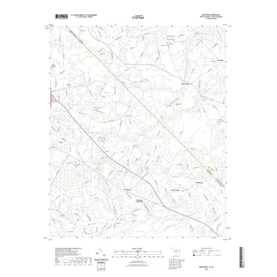
2022 Map of Goretown
USGS Topo · Published 2022About this map
The town of Loris anchors the western edge of this 2022 survey, which covers a transition between the South Carolina border and the intricate wetlands of Horry County. Small rural settlements like Goretown and Grahams Crossroads sit at the intersection of local routes, surrounded by family-named cemeteries such as Flag Patch Cem and Springfield Cem that provide valuable data for local genealogists.
Find a feature on this map
152 named features on this map. Tap any name to fly to it.
Don’t see what you’re looking for? This feature index may not catch every label — zoom into the map to look around manually.
Map Details
Editions of this 2022 Goretown Map
This is the sole edition of this map. No revisions or reprints were ever made.
Other maps of this area

1937 · Nixonville
USGS Topo · 1:48,000

1942 · Nixonville
USGS Topo · 1:62,500

1943 · Pireway
USGS Topo · 1:31,680

1943 · Nakina
USGS Topo · 1:24,000

1944 · Longs
USGS Topo · 1:31,680

1949 · Georgetown
USGS Topo · 1:250,000

1953 · Longs
USGS Topo · 1:24,000
1953 · Pireway
USGS Topo · 1:24,000

1953 · Florence
USGS Topo · 1:250,000

1954 · Florence
USGS Topo · 1:250,000