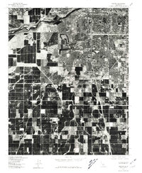
1978 Map of Gosford
USGS Topo · Published 1981About this map
Kern City and the expanding residential outskirts of Bakersfield dominate the northern portion of this 1978 orthophotograph, where planned housing developments contrast sharply with the surrounding agricultural grid. The imagery, produced by the Geological Survey in cooperation with the Soil Conservation Service, documents the transition from high-density urban planning to the large-scale industrial farming operations of the southern San Joaquin Valley. Further south, smaller communities like Gosford, Pumpkin Center, and Old River appear as concentrated hubs amidst a geometric landscape of fields and canals. This visual record captures the precise footprint of Kern County's development during the late 1970s, illustrating the spatial relationship between its growing suburbs and the established rural settlements that defined its earlier agrarian identity.
Find a feature on this map
5 named features on this map. Tap any name to fly to it.
Don’t see what you’re looking for? This feature index may not catch every label — zoom into the map to look around manually.
Map Details
Editions of this 1978 Gosford Map
This is the sole edition of this map. No revisions or reprints were ever made.
Other maps of this area

1906 · Bakersfield
USGS Topo · 1:62,500

1910 · Buena Vista Lake
USGS Topo · 1:125,000

1912 · Buena Vista Lake
USGS Topo · 1:125,000

1914 · Caliente
USGS Topo · 1:125,000

1929 · Stevens
USGS Topo · 1:31,680

1929 · Fairfax School
USGS Topo · 1:31,680

1930 · Weed Patch
USGS Topo · 1:31,680

1930 · Millux
USGS Topo · 1:31,680

1930 · Rosedale
USGS Topo · 1:31,680

1930 · Conner
USGS Topo · 1:31,680