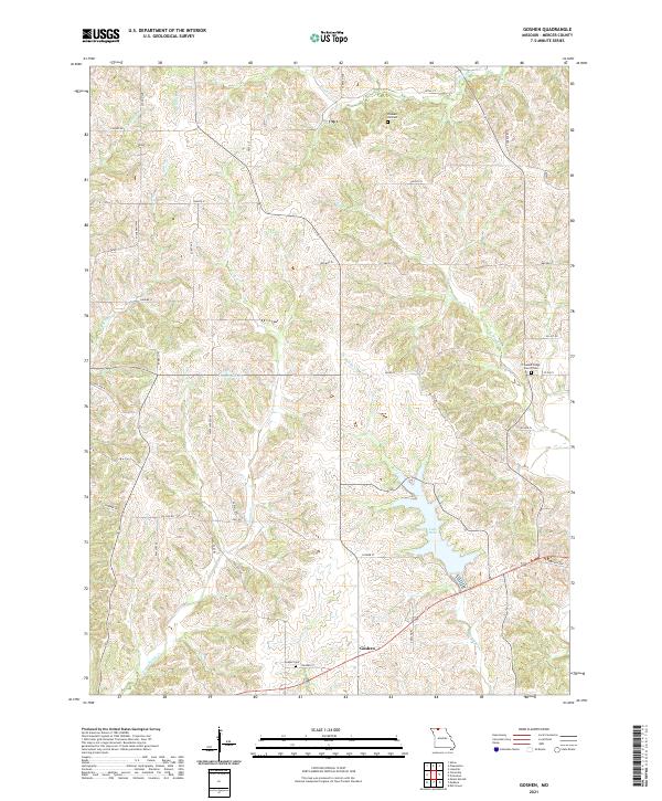
2021 Map of Goshen
USGS Topo · Published 2021About this map
Goshen is a small rural community in Mercer County, defined by a network of creeks and small lakes in the northern Missouri landscape. Modern infrastructure like Lake Paho and Campbell Lake interrupt the natural drainage of Sandy Cr and W Muddy Cr, which flow through the undulating terrain. The area's history is anchored by its burial grounds, including the Goshen Cem south of the main settlement and Pleasant Hill Cem to the north. These sites, along with Pleasant Ridge Church Cem, serve as primary landmarks for genealogists and local historians tracing families in this agricultural region. The map shows a transition from traditional section-line roads like E 170th St to newer residential naming conventions such as Fantail Avenue and Falcon Rd.
Find a feature on this map
47 named features on this map. Tap any name to fly to it.
Don’t see what you’re looking for? This feature index may not catch every label — zoom into the map to look around manually.
Map Details
Editions of this 2021 Goshen Map
This is the sole edition of this map. No revisions or reprints were ever made.
Other maps of this area

1945 · Lamoni
USGS Topo · 1:62,500

1946 · Princeton
USGS Topo · 1:62,500

1947 · Lamoni
USGS Topo · 1:62,500

1947 · Blythedale
USGS Topo · 1:62,500

1948 · Princeton
USGS Topo · 1:62,500

1954 · Centerville
USGS Topo · 1:250,000

1957 · Centerville
USGS Topo · 1:250,000

1958 · Centerville
USGS Topo · 1:250,000

1964 · Pleasanton
USGS Topo · 1:24,000
1964 · Lineville
USGS Topo · 1:24,000