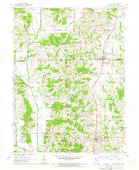
1964 Map of Lineville
USGS Topo · Published 1966About this map
Lineville and South Lineville straddle the state line in this mid-1960s survey, illustrating a unique community divided between Iowa and Missouri. The Chicago Rock Island and Pacific railroad serves as the primary north-south axis, connecting these settlements with Mercer to the south. The landscape is defined by the winding course of the Weldon River and the Grand River, which cut through the drainage basins of Sand Creek and Mineral Springs Branch. Genealogists will find a high density of rural burial sites, including Evergreen Cemetery, Girdner Cem, and Logan Cem, many of which appear alongside small homesteads and family farms. The inclusion of a Gaging Station on the river and a Substation near Mercer highlights the essential infrastructure supporting these border-region agricultural communities during this era of rural development.
Find a feature on this map
39 named features on this map. Tap any name to fly to it.
Don’t see what you’re looking for? This feature index may not catch every label — zoom into the map to look around manually.
Map Details
Editions of this 1964 Lineville Map
This is the sole edition of this map. No revisions or reprints were ever made.
Other maps of this area

1946 · Princeton
USGS Topo · 1:62,500

1948 · Princeton
USGS Topo · 1:62,500

1954 · Centerville
USGS Topo · 1:250,000

1957 · Centerville
USGS Topo · 1:250,000

1958 · Centerville
USGS Topo · 1:250,000

1964 · Ravanna
USGS Topo · 1:24,000

1964 · Woodland
USGS Topo · 1:24,000

1964 · Pleasanton
USGS Topo · 1:24,000

1964 · Cleopatra
USGS Topo · 1:24,000

1964 · Leon
USGS Topo · 1:24,000