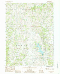
1984 Map of Goshen
USGS Topo · Published 1985About this map
Goshen sits at the heart of this North Missouri landscape, where the agricultural uplands of Harrison and Morgan townships meet a dense network of waterways. The terrain is defined by the winding paths of Brush Creek and Sandy Creek, which drain the rolling countryside. A significant portion of the southeastern quadrant is occupied by the Lake Paho State Wildlife Area, centered on the expansive waters of Lake Paho. This reservoir and its surrounding managed lands represent a shift in the local environment toward conservation and recreation during the late 20th century. The intricate drainage patterns of West Muddy Creek and Martin Creek provide a clear view of the natural hydrology that shaped the area's development before modern road networks connected the scattered farmsteads and rural routes seen here in the mid-1980s.
Find a feature on this map
13 named features on this map. Tap any name to fly to it.
Don’t see what you’re looking for? This feature index may not catch every label — zoom into the map to look around manually.
Map Details
Editions of this 1984 Goshen Map
This is the sole edition of this map. No revisions or reprints were ever made.
Other maps of this area

1945 · Lamoni
USGS Topo · 1:62,500

1946 · Princeton
USGS Topo · 1:62,500

1947 · Lamoni
USGS Topo · 1:62,500

1947 · Blythedale
USGS Topo · 1:62,500

1948 · Princeton
USGS Topo · 1:62,500

1954 · Centerville
USGS Topo · 1:250,000

1957 · Centerville
USGS Topo · 1:250,000

1958 · Centerville
USGS Topo · 1:250,000

1964 · Pleasanton
USGS Topo · 1:24,000
1964 · Lineville
USGS Topo · 1:24,000